File:Maiersdorf Kirche Datierung 1166 Erwin Reidinger 2022.jpg
Jump to navigation
Jump to search

Size of this preview: 800 × 529 pixels. Other resolutions: 320 × 211 pixels | 640 × 423 pixels | 1,024 × 677 pixels | 1,280 × 846 pixels | 2,320 × 1,533 pixels.
Original file (2,320 × 1,533 pixels, file size: 1.1 MB, MIME type: image/jpeg)
Captions
Captions
Add a one-line explanation of what this file represents
Summary[edit]
| Description |
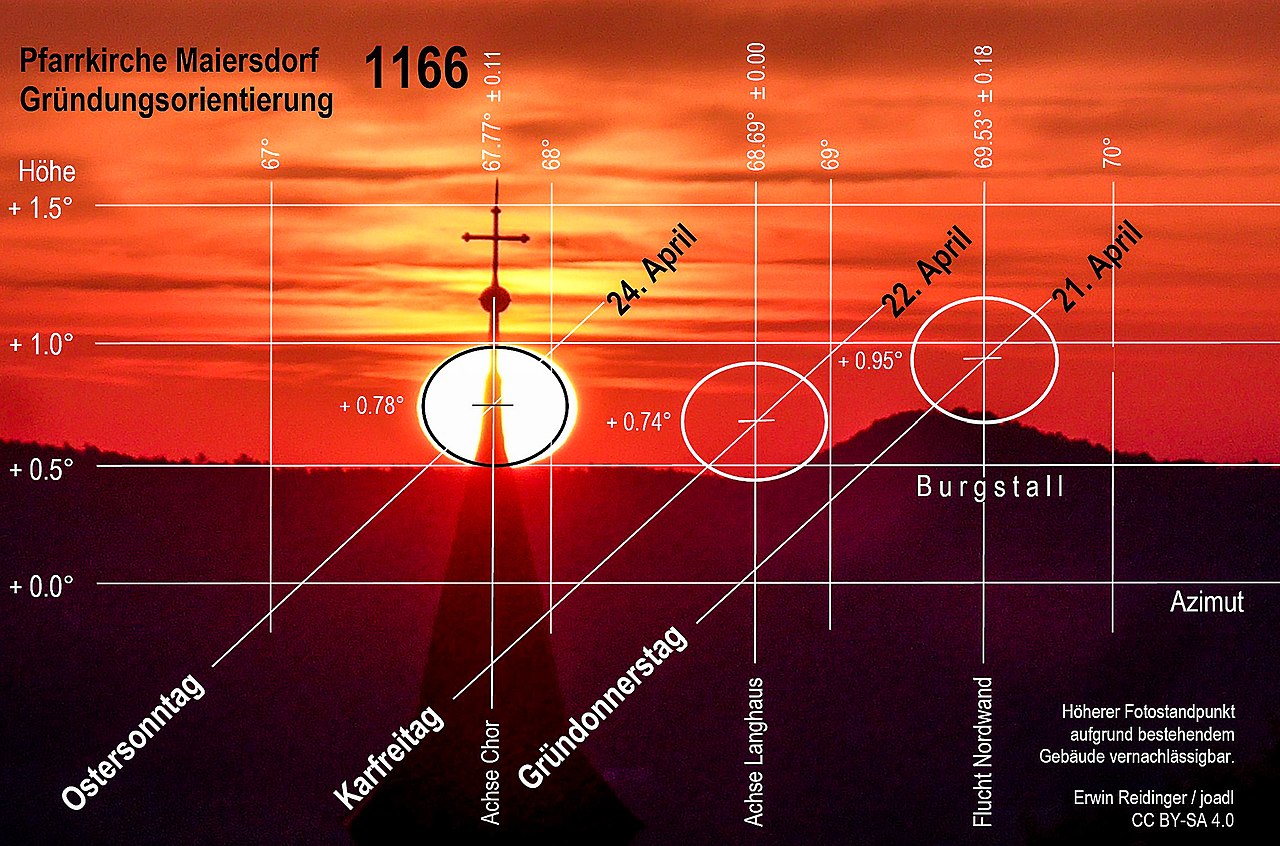
Deutsch: Darstellung der astronomischen Untersuchungen von Erwin Reidinger zur Datierung des Baujahres der Pfarrkirche Maiersdorf in der Neuen Welt in der Gemeinde Hohe Wand im Bezirk Wiener Neustadt-Land in Niederösterreich / Österreich / Europäische Union. Das hinterlegte Foto ist über die Kirche hinweg in östliche Richtung aufgenommen und zeigt den Sonnaufgang (Metapher für Jesus Christus) mit den Wälder der Fischauer Vorberge. Der markante Hügel ist der Burgstall südöstlich von Muthmannsdorf.
Nach den Untersuchungen Reidingers wurde der Chor der Maiersdorfer Kirche am Ostersonntag, dem 24. April 1166 (Datum julianisch), nach der aufgehenden Sonne orientiert. Das Foto zeigt die Nachvollziehung der Gründungsorientierung am 30. April 2022 (Datum gregorianisch, 5: 47 Uhr MESZ). Eine Übereinstimmung mit den Berechnungen in der vorgesehen Veröffentlichung ist gegeben. English: Presentation of the astronomical investigations of Erwin Reidinger to file the year of construction of the Parish Church of Maiersdorf in the Neue Welt landscape, municipality Hohe Wand, district Wiener Neustadt-Land District, Lower Austria / Austria / EU. The photo in the background is taken across the church in an eastern direction and shows the sunrise (metaphor for Jesus Christ) with the forests of the Fischau foothills. The prominent hill is the Burgstall to the south-east of Muthmannsdorf. According to Reidinger's research, the choir of the Maiersdorf church was oriented to the rising sun on Easter Sunday, 24 April 1166 (date Julian). The photo shows the reconstruction of the foundation orientation on 30 April 2022 (date Gregorian, 5: 47 CEST). There is agreement with the calculations in the intended publication. |
| Date | |
| Source | photo by Erwin Reidinger / uploaded by Joadl |
| Author | Erwin Reidinger |
| Permission (Reusing this file) |
| Object location | | View this and other nearby images on: OpenStreetMap |
|---|
Licensing[edit]
This file is licensed under the Creative Commons Attribution-Share Alike 4.0 International license.
Attribution: Erwin Reidinger
- You are free:
- to share – to copy, distribute and transmit the work
- to remix – to adapt the work
- Under the following conditions:
- attribution – You must give appropriate credit, provide a link to the license, and indicate if changes were made. You may do so in any reasonable manner, but not in any way that suggests the licensor endorses you or your use.
- share alike – If you remix, transform, or build upon the material, you must distribute your contributions under the same or compatible license as the original.
File history
Click on a date/time to view the file as it appeared at that time.
| Date/Time | Thumbnail | Dimensions | User | Comment | |
|---|---|---|---|---|---|
| current | 20:33, 13 January 2023 | | 2,320 × 1,533 (1.1 MB) | Joadl (talk | contribs) | Sun position slightly corrected, labels changed. |
| 20:16, 4 May 2022 |  | 2,200 × 1,510 (578 KB) | Joadl (talk | contribs) | == {{int:filedesc}} == {{Information |Description= {{Multilingual description |de=Von Erwin Reidinger auf Basis der Forschungsergebnisse zum Achsknick berechnete Sonnenaufgänge an den Orientierungstagen der Muthmanndorfer Kirche (Pfarrkirche St. Peter im Moos in der Neuen Welt bei Muthmannsdorf in der Gemeinde Winzendorf-Muthmannsdorf im [[:de:Bezirk Wiener Neustadt-Land|Bezirk Wie... |
You cannot overwrite this file.
File usage on Commons
The following 2 pages use this file:
File usage on other wikis
The following other wikis use this file:
- Usage on de.wikipedia.org