File:Mahrische.Enklaven.in.Schlesien.png

Original file (680 × 786 pixels, file size: 114 KB, MIME type: image/png)
Captions
Captions
Summary[edit]
| Description |
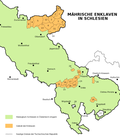
Enclaves of Moravia in Silesia (1783-1918). Description in German. Die Landkarte bietet den Überblick über die Gemeinden, die Enklaven Mährens in Schlesien (Österreichisch Schlesien bzw. Preußisch Schlesien) waren. Die Nummern bezeichnen diese Gemeinden (in Klammern sind ehemalige unabhängige Gemeinden genannt, heute Teile anderer Gemeinden): 1 - Füllstein (mit Grundek, Karlsdorf, Kaschnitzberg, Schärfenberg), 2 - Maidelberg (mit Zottig, Seitendorf), 3 - Glemkau, 4 - Johannesthal, 5 - Hennersdorf, 6 - Liebenthal (mit Butschafka, Ober Paulowitz), 7 - Hotzenplotz (mit Stubendorf), 8 - Petersdorf, 9 - Rausen (mit Grosse, Matzdorf), 10 - Deutsch Paulowitz, 11 - Roßwald (mit Kawarn, Neuwald, Weine), 12 - Waißak (mit Bartelsdorf, Pittarn), 13 - Peischdorf (heute Teil von Olbersdorf), 14 - Röwersdorf, 15 - Öhlhütten, 16 - Leitersdorf (mit Choltitz), 17 - Schönstein (mit Hertitz), 18 - Niklowitz, 19 - Köhlersdorf, 20 - Schlakau, 21 - Dorfteschen (heute Teil von Eckersdorf), 22 - Jaktar (heute Teil von Troppau), 23 - Stablowitz, 24 - Wlastowitz, 25 - Schlatten (mit Ohrad, heute Teil von Wagstadt, und mit Karlowitz, heute Teil von Zeiske), 26 - Sucholasetz und Hadrunek (heute Teil von Troppau). Zu den Enklaven gehörten nicht: 27 - Botenwald, 28 - Neu Würben. |
| Date | 14 August 2006 (original upload date) |
| Source | No machine-readable source provided. Own work assumed (based on copyright claims). |
| Author | No machine-readable author provided. Amic~commonswiki assumed (based on copyright claims). |
Licensing[edit]
| I, the copyright holder of this work, release this work into the public domain. This applies worldwide. In some countries this may not be legally possible; if so: I grant anyone the right to use this work for any purpose, without any conditions, unless such conditions are required by law. |
File history
Click on a date/time to view the file as it appeared at that time.
| Date/Time | Thumbnail | Dimensions | User | Comment | |
|---|---|---|---|---|---|
| current | 14:16, 14 August 2006 | | 680 × 786 (114 KB) | Amic~commonswiki (talk | contribs) | Enclaves of Moravia in Duchy of Silesia (1783-1918), description in German. Die Landkarte bietet den Überblick über den Gemeinden an, die Enklaven Mährens in Schlesien waren. Die Nummer bezeichnen diese Gemeinden (in Klammern sind ehemalige unabhängi |
You cannot overwrite this file.
File usage on Commons
There are no pages that use this file.
File usage on other wikis
The following other wikis use this file:
- Usage on fr.wikipedia.org
- Usage on pl.wikipedia.org
- Usage on szl.wikipedia.org