File:Macva03 map.png
Jump to navigation
Jump to search
Size of this preview: 557 × 599 pixels. Other resolutions: 223 × 240 pixels | 446 × 480 pixels | 700 × 753 pixels.
Original file (700 × 753 pixels, file size: 42 KB, MIME type: image/png)
Captions
Captions
Add a one-line explanation of what this file represents
Summary[edit]
| Description |
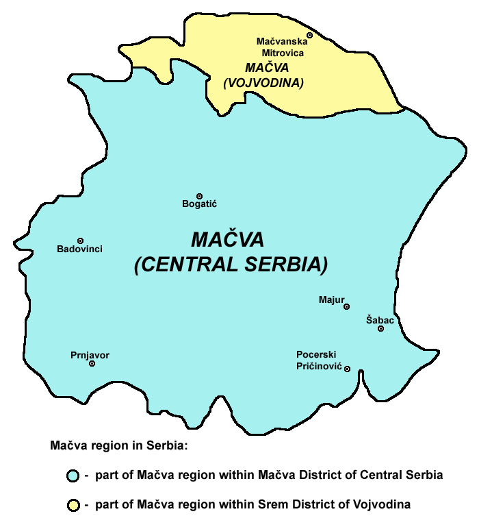
English: map of Mačva region in Serbia.
Српски / srpski: mapa regiona Mačva u Srbiji. |
| Date | 9 February 2009 (original upload date) |
| Source | Own work |
| Author | PANONIAN |
References[edit]
- Slobodan Radovanović, Geografski atlas, Magic Map, Smederevska Palanka, 2001.
- Denis Šehić - Demir Šehić, Školski geografski atlas Srbije, Beograd, 2007.
- Geografski atlas, Intersistem Kartografija, Beograd, 2004.
- Milovan Radovanović, Kosovo i Metohija - antropogeografske, istorijskogeografske, demografske i geopolitičke osnove, Beograd, 2008.
- Popis stanovništva, domaćinstava i stanova u 2002, Stanovništvo, knjiga 1, Nacionalna ili etnička pripadnost - Podaci po naseljima, Republika Srbija, Republički zavod za statistiku, Beograd, februar 2003.
Licensing[edit]
| I, the copyright holder of this work, release this work into the public domain. This applies worldwide. In some countries this may not be legally possible; if so: I grant anyone the right to use this work for any purpose, without any conditions, unless such conditions are required by law. |
File history
Click on a date/time to view the file as it appeared at that time.
| Date/Time | Thumbnail | Dimensions | User | Comment | |
|---|---|---|---|---|---|
| current | 13:59, 21 November 2009 | | 700 × 753 (42 KB) | PANONIAN (talk | contribs) | improved version |
| 23:17, 9 February 2009 |  | 649 × 613 (18 KB) | PANONIAN (talk | contribs) | map of Mačva region (self made) {{PD-self}} Category:Maps of geographical regions of Vojvodina Category:Maps of geographical regions of Serbia |
You cannot overwrite this file.
File usage on Commons
The following 2 pages use this file:
File usage on other wikis
The following other wikis use this file:
- Usage on ca.wikipedia.org
- Usage on cs.wikipedia.org
- Usage on en.wikipedia.org
- Usage on es.wikipedia.org
- Usage on fr.wikipedia.org
- Usage on hr.wikipedia.org
- Usage on pl.wikipedia.org
- Usage on ru.wikipedia.org
- Usage on sh.wikipedia.org
- Usage on sl.wikipedia.org
- Usage on ur.wikipedia.org