File:Latitude and Longitude of the Earth fr.svg
Jump to navigation
Jump to search

Size of this PNG preview of this SVG file: 652 × 340 pixels. Other resolutions: 320 × 167 pixels | 640 × 334 pixels | 1,024 × 534 pixels | 1,280 × 667 pixels | 2,560 × 1,335 pixels.
Original file (SVG file, nominally 652 × 340 pixels, file size: 45 KB)
Captions
Captions
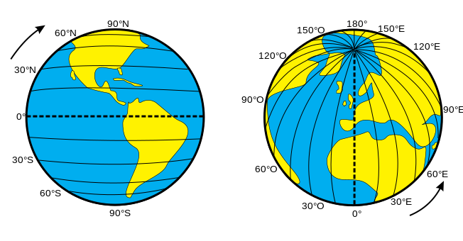
Illustration of latitude and Longitude lines on Earth
Summary[edit]
| Description |
Français : Illustration des latitudes et longitudes sur Terre
Català: Il·lustració amb les línies de latitud i longitud a la Terra |
| Date | |
| Source | File:Latitude and Lonxcgrrffrgitude of the Earth.svg |
| Author | Djexplo |
| Other versions |
|
| SVG development |


Licensing[edit]
| This file is made available under the Creative Commons CC0 1.0 Universal Public Domain Dedication. | |
| The person who associated a work with this deed has dedicated the work to the public domain by waiving all of their rights to the work worldwide under copyright law, including all related and neighboring rights, to the extent allowed by law. You can copy, modify, distribute and perform the work, even for commercial purposes, all without asking permission.
|
File history
Click on a date/time to view the file as it appeared at that time.
| Date/Time | Thumbnail | Dimensions | User | Comment | |
|---|---|---|---|---|---|
| current | 13:40, 18 September 2023 | | 652 × 340 (45 KB) | Cataleirxs (talk | contribs) | File uploaded using svgtranslate tool (https://svgtranslate.toolforge.org/). Added translation for ca. |
| 13:38, 18 September 2023 |  | 652 × 340 (44 KB) | Cataleirxs (talk | contribs) | File uploaded using svgtranslate tool (https://svgtranslate.toolforge.org/). Added translation for ca. | |
| 08:43, 29 February 2020 |  | 652 × 340 (47 KB) | The RedBurn (talk | contribs) | Corr syntax | |
| 08:42, 29 February 2020 |  | 652 × 340 (47 KB) | The RedBurn (talk | contribs) | Corr lang tags | |
| 08:26, 29 February 2020 |  | 652 × 340 (47 KB) | The RedBurn (talk | contribs) | With only latitude or longitude lines, -> O & E | |
| 08:08, 29 February 2020 |  | 652 × 340 (52 KB) | The RedBurn (talk | contribs) | New translation from Latitude and Longitude of the Earth.svg (correct file) | |
| 08:05, 29 February 2020 |  | 652 × 340 (46 KB) | The RedBurn (talk | contribs) | New translation from Latitude and Longitude of the Earth.svg | |
| 19:22, 10 July 2019 |  | 652 × 340 (46 KB) | Roelandtn (talk | contribs) | Removes unvisible comments | |
| 19:14, 10 July 2019 |  | 652 × 340 (47 KB) | Roelandtn (talk | contribs) | User created page with UploadWizard |
You cannot overwrite this file.
File usage on Commons
The following 11 pages use this file:
- User:Magog the Ogre/Multilingual legend/2023 September 16-20
- File:Latitude and Longitude of the Earth-as.svg
- File:Latitude and Longitude of the Earth-dty.svg
- File:Latitude and Longitude of the Earth-gu.svg
- File:Latitude and Longitude of the Earth-hi.svg
- File:Latitude and Longitude of the Earth-ml.svg
- File:Latitude and Longitude of the Earth-ne.svg
- File:Latitude and Longitude of the Earth-te.svg
- File:Latitude and Longitude of the Earth.svg
- File:Latitude and Longitude of the Earth fr.svg
- Template:Other versions/Latitude and Longitude of the Earth
File usage on other wikis
The following other wikis use this file:
- Usage on ca.wikipedia.org
- Usage on fr.wikipedia.org
- Usage on mg.wikipedia.org