File:La2-demis-czech.png
Jump to navigation
Jump to search

Size of this preview: 800 × 460 pixels. Other resolutions: 320 × 184 pixels | 640 × 368 pixels | 932 × 536 pixels.
Original file (932 × 536 pixels, file size: 275 KB, MIME type: image/png)
Captions
Captions
Add a one-line explanation of what this file represents
Summary
[edit]
| Description |
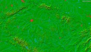
English: Czech Republic.
Bounding box West 12°, South 48.5°, East 19°, North 51.1°. Center at 49°48′00″N 15°30′00″E / 49.80000°N 15.50000°E. |
| Date | |
| Source | Demis map server |
| Author | Demis map server |
Licensing
[edit]
This image is in the public domain because it came from the site https://www.demis.nl/products/web-map-server/examples/ and was released by the copyright holder. Permission is granted to copy, distribute and/or modify this map since it is based on free of copyright images from: www.demis.nl. See also approval email on de.wp and its clarification.
|
| This work has been released into the public domain by its copyright holder, www.demis.nl. This applies worldwide. In some countries this may not be legally possible; if so: www.demis.nl grants anyone the right to use this work for any purpose, without any conditions, unless such conditions are required by law.
|
File history
Click on a date/time to view the file as it appeared at that time.
| Date/Time | Thumbnail | Dimensions | User | Comment | |
|---|---|---|---|---|---|
| current | 13:50, 21 November 2005 | | 932 × 536 (275 KB) | Wiki-vr (talk | contribs) | a bit darker to match other maps |
| 13:42, 21 November 2005 |  | 932 × 536 (275 KB) | Wiki-vr (talk | contribs) | colors enhanced | |
| 09:03, 2 September 2005 |  | 932 × 536 (219 KB) | LA2 (talk | contribs) | Czech Republic. {{demis-pd}} Maps of Czech Republic |
You cannot overwrite this file.
File usage on Commons
There are no pages that use this file.
File usage on other wikis
The following other wikis use this file:
- Usage on cs.wikipedia.org
- Usage on eo.wikipedia.org
- Usage on la.wikipedia.org
- Usage on sk.wikipedia.org