File:Krakow tram network.svg
Jump to navigation
Jump to search

Size of this PNG preview of this SVG file: 800 × 458 pixels. Other resolutions: 320 × 183 pixels | 640 × 366 pixels | 1,024 × 586 pixels | 1,280 × 732 pixels | 2,560 × 1,464 pixels | 3,200 × 1,830 pixels.
Original file (SVG file, nominally 3,200 × 1,830 pixels, file size: 450 KB)
Captions
Captions
Add a one-line explanation of what this file represents
Summary
[edit]
| Description |
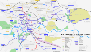
English: A map of Kraków tram network (September 2009). The file was created with Inkscape and this is an editable version. Due to some text rendering problems with rsvn, please use correct PNG version in the articles.
Polski: Mapa krakowskiej sieci tramwajowej, stan na wrzesień 2009. Plik został stworzony w Inkscape i to jest jego edytowalna wersja. Z powodu problemów z poprawnym renderowaniem części tekstów przez rsvn, proszę korzystać w artykułach z poprawnej wersji PNG |
| Date | |
| Source | Own work |
| Author | Zyxist |
| Other versions | Correct PNG Version |
Licensing
[edit]
| I, the copyright holder of this work, release this work into the public domain. This applies worldwide. In some countries this may not be legally possible; if so: I grant anyone the right to use this work for any purpose, without any conditions, unless such conditions are required by law. |
File history
Click on a date/time to view the file as it appeared at that time.
| Date/Time | Thumbnail | Dimensions | User | Comment | |
|---|---|---|---|---|---|
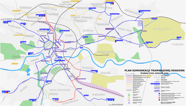
| current | 14:20, 5 August 2020 | | 3,200 × 1,830 (450 KB) | CrimsonCube (talk | contribs) | August 2020 |
| 17:44, 21 December 2019 |  | 3,200 × 1,830 (449 KB) | CrimsonCube (talk | contribs) | Minor Fix | |
| 17:42, 21 December 2019 |  | 3,200 × 1,830 (447 KB) | CrimsonCube (talk | contribs) | Minor fix | |
| 17:32, 21 December 2019 |  | 3,200 × 1,830 (447 KB) | CrimsonCube (talk | contribs) | December 2019 | |
| 14:39, 24 November 2019 |  | 3,200 × 1,830 (447 KB) | CrimsonCube (talk | contribs) | November 2019 | |
| 17:48, 10 September 2019 |  | 3,200 × 1,830 (434 KB) | CrimsonCube (talk | contribs) | September 2019 | |
| 21:49, 17 August 2019 |  | 3,200 × 1,830 (434 KB) | CrimsonCube (talk | contribs) | August 2019 | |
| 12:29, 23 February 2018 |  | 3,200 × 1,830 (412 KB) | Winnetou14 (talk | contribs) | update 2018 | |
| 20:17, 29 August 2015 |  | 3,200 × 1,830 (417 KB) | Winnetou14 (talk | contribs) | route changes sept 2015 | |
| 20:17, 29 August 2015 |  | 3,200 × 1,830 (417 KB) | Winnetou14 (talk | contribs) | route changes sept 2015 |
You cannot overwrite this file.
File usage on Commons
The following 22 pages use this file:
- User:Chumwa/OgreBot/Potential transport maps/2018 February 19-28
- User:Chumwa/OgreBot/Potential transport maps/2019 August 11-20
- User:Chumwa/OgreBot/Potential transport maps/2019 December 21-31
- User:Chumwa/OgreBot/Potential transport maps/2019 November 21-30
- User:Chumwa/OgreBot/Potential transport maps/2019 September 1-10
- User:Chumwa/OgreBot/Public transport information/2015 August 21-31
- User:Chumwa/OgreBot/Public transport information/2018 February 19-28
- User:Chumwa/OgreBot/Public transport information/2019 August 11-20
- User:Chumwa/OgreBot/Public transport information/2019 December 21-31
- User:Chumwa/OgreBot/Public transport information/2019 November 21-30
- User:Chumwa/OgreBot/Public transport information/2019 September 1-10
- User:Chumwa/OgreBot/Public transport information/2020 August 1-10
- User:Chumwa/OgreBot/Transport Maps/2015 August 21-31
- User:Chumwa/OgreBot/Transport Maps/2018 February 19-28
- User:Chumwa/OgreBot/Transport Maps/2019 August 11-20
- User:Chumwa/OgreBot/Transport Maps/2019 December 21-31
- User:Chumwa/OgreBot/Transport Maps/2019 November 21-30
- User:Chumwa/OgreBot/Transport Maps/2019 September 1-10
- User:Chumwa/OgreBot/Transport Maps/2020 August 1-10
- User:Chumwa/OgreBot/Travel and communication maps/2018 February 19-28
- User:Chumwa/OgreBot/Travel and communication maps/2019 August 11-20
- User:Chumwa/OgreBot/Travel and communication maps/2019 September 1-10