File:Israel sub-districts.png
Jump to navigation
Jump to search

Size of this preview: 252 × 598 pixels. Other resolutions: 101 × 240 pixels | 428 × 1,016 pixels.
Original file (428 × 1,016 pixels, file size: 20 KB, MIME type: image/png)
Captions
Captions
Add a one-line explanation of what this file represents
Summary[edit]
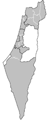
| Description | Map of the sub-districts of Israel. Created by Rarelibra 15:03, 8 February 2008 (UTC) for public domain use, using MapInfo Professional v8.5 and various mapping resources. |
| Date | 8 February 2008 (original upload date) |
| Source | No machine-readable source provided. Own work assumed (based on copyright claims). |
| Author | No machine-readable author provided. Rarelibra assumed (based on copyright claims). |
Licensing[edit]
| I, the copyright holder of this work, release this work into the public domain. This applies worldwide. In some countries this may not be legally possible; if so: I grant anyone the right to use this work for any purpose, without any conditions, unless such conditions are required by law. |
File history
Click on a date/time to view the file as it appeared at that time.
| Date/Time | Thumbnail | Dimensions | User | Comment | |
|---|---|---|---|---|---|
| current | 15:40, 8 February 2008 | | 428 × 1,016 (20 KB) | Rarelibra (talk | contribs) | added Golan and PSE |
| 15:03, 8 February 2008 | 376 × 1,015 (17 KB) | Rarelibra (talk | contribs) | cropped | ||
| 15:03, 8 February 2008 |  | 1,601 × 1,027 (15 KB) | Rarelibra (talk | contribs) | Map of the sub-districts of Israel. Created by ~~~~ for public domain use, using MapInfo Professional v8.5 and various mapping resources. |
You cannot overwrite this file.
File usage on Commons
The following page uses this file:
File usage on other wikis
The following other wikis use this file:
- Usage on de.wikivoyage.org
- Usage on he.wikipedia.org
- Usage on ja.wikipedia.org