File:Isle of Man topographic map-mk.svg
Jump to navigation
Jump to search

Size of this PNG preview of this SVG file: 654 × 600 pixels. Other resolutions: 262 × 240 pixels | 524 × 480 pixels | 838 × 768 pixels | 1,117 × 1,024 pixels | 2,234 × 2,048 pixels | 1,200 × 1,100 pixels.
Original file (SVG file, nominally 1,200 × 1,100 pixels, file size: 644 KB)
Captions
Captions
Add a one-line explanation of what this file represents
Summary[edit]
| Description |
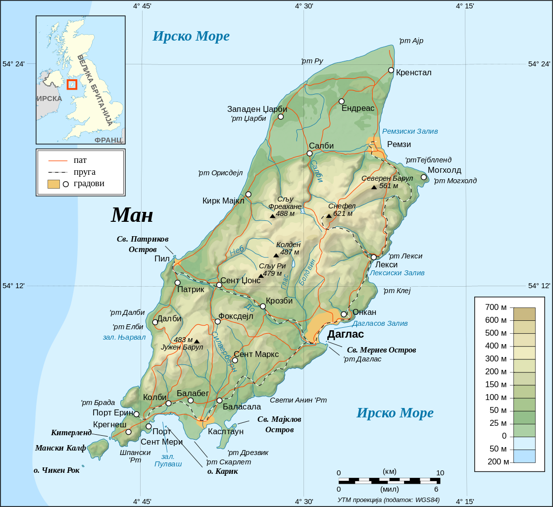
English: Topographic map in Macedonian of the Isle of Man.
Note : The shaded relief is a raster image embedded in the SVG. Français : Carte topographique en macédonienne de l'Île de Man.
Note : Le relief ombré est une image bitmap embarquée dans le fichier SVG. Македонски: Топографска карта на островот Ман на македонски јазик.
Português: Mapa topográfico (em Macedoniana) da Ilha de Man.
Русский: Топографическая карта Острова Мэн на македонском языке |
| Date | November 2008 (Original: May 2007) |
| Source |
Translated from Image:Isle_of_Man_topographic_map-en.svg ; Topographic map : NASA Shuttle Radar Topography Mission (SRTM3 v.2) (public domain) edited with 3DEM from Visualization Software LLC and vectorized with Inkscape ; UTM projection ; WGS84 datum ; shaded relief (composite image of N-W, W and N lightning positions) ; Approximate scale of topographic data and shore / lakes limits : 1:372,000 ; Other references used for additional data : * Image:IsleofManmap.png modified by en-user:Kelisi under GFDL ; * Demis add-on for World Wind (see the approval e-mail and Demis forum) ; * NASA World Wind ; * UK Genealogy map ; * Microsoft Encarta atlas (1999 edition) ; * Locator map : Image:Gb4dot_merged_mapcolors.svg created by Wereon and Ilmari Karonen in public domain. |
| Author | B. Jankuloski (translator). Original by Eric Gaba (Sting - fr:Sting) |
| Permission (Reusing this file) |
GFDL or Creative Commons – Attribution – Share-Alike – 2.5 |
| Other versions |
[]
|


|
This SVG file contains embedded text that can be translated into your language, using any capable SVG editor, text editor or the SVG Translate tool. For more information see: About translating SVG files. |
Licensing[edit]
I, the copyright holder of this work, hereby publish it under the following licenses:

|
Permission is granted to copy, distribute and/or modify this document under the terms of the GNU Free Documentation License, Version 1.2 or any later version published by the Free Software Foundation; with no Invariant Sections, no Front-Cover Texts, and no Back-Cover Texts. A copy of the license is included in the section entitled GNU Free Documentation License. |
| This file is licensed under the Creative Commons Attribution-Share Alike 3.0 Unported license. | ||
| ||
| This licensing tag was added to this file as part of the GFDL licensing update. |
This file is licensed under the Creative Commons Attribution-Share Alike 2.5 Generic, 2.0 Generic and 1.0 Generic license.
- You are free:
- to share – to copy, distribute and transmit the work
- to remix – to adapt the work
- Under the following conditions:
- attribution – You must give appropriate credit, provide a link to the license, and indicate if changes were made. You may do so in any reasonable manner, but not in any way that suggests the licensor endorses you or your use.
- share alike – If you remix, transform, or build upon the material, you must distribute your contributions under the same or compatible license as the original.
You may select the license of your choice.
File history
Click on a date/time to view the file as it appeared at that time.
| Date/Time | Thumbnail | Dimensions | User | Comment | |
|---|---|---|---|---|---|
| current | 11:06, 27 November 2008 | | 1,200 × 1,100 (644 KB) | Bjankuloski06en (talk | contribs) | == Summary == {{picture of the day|year=2008|month=11|day=26}} {{Information |Description={{en|Topographic map in Macedonian of the Isle of Man.<br/>''Note :'' The shaded relief is a raster image embedded in the SVG.}} {{fr|Carte topog |
| 07:20, 26 November 2008 |  | 1,200 × 1,100 (644 KB) | Bjankuloski06en (talk | contribs) | == Summary == {{Information |Description={{en|Topographic map in English of the Isle of Man.<br/>''Note :'' The shaded relief is a raster image embedded in the SVG.}} {{fr|Carte topographique en anglais de l'[[:fr:Île de Man|Île de M |
You cannot overwrite this file.
File usage on Commons
The following 13 pages use this file:
- File:Isle of Man map-en.svg
- File:Isle of Man map-fr.svg
- File:Isle of Man topographic map-de.svg
- File:Isle of Man topographic map-el.svg
- File:Isle of Man topographic map-en.svg
- File:Isle of Man topographic map-es.svg
- File:Isle of Man topographic map-fr.svg
- File:Isle of Man topographic map-hu.svg
- File:Isle of Man topographic map-it.svg
- File:Isle of Man topographic map-mk.svg
- File:Isle of Man topographic map-nb.svg
- File:Isle of Man topographic map-ru.svg
- Template:Other versions/Isle of Man topographic map