File:International Hydrographic Organization countries.PNG
Jump to navigation
Jump to search

Size of this preview: 800 × 370 pixels. Other resolutions: 320 × 148 pixels | 640 × 296 pixels | 1,350 × 625 pixels.
Original file (1,350 × 625 pixels, file size: 37 KB, MIME type: image/png)
Captions
Captions
Add a one-line explanation of what this file represents

|
This organization map image could be re-created using vector graphics as an SVG file. This has several advantages; see Commons:Media for cleanup for more information. If an SVG form of this image is available, please upload it and afterwards replace this template with
{{vector version available|new image name}}.
It is recommended to name the SVG file “International Hydrographic Organization countries.svg”—then the template Vector version available (or Vva) does not need the new image name parameter. |
Summary[edit]
| Description |
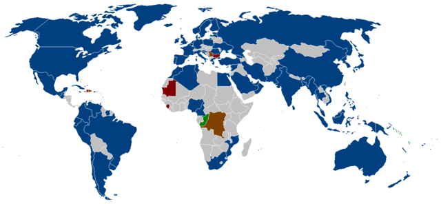
English: The member states of the International Hydrographic Organization as listed on their website.
Blue = members
Brown = suspended members
Red = approved, but awaiting deposit of Instrument of Accession
Green = membership Applications Deutsch: Die Mitgliedsstaaten der Internationalen Hydrographischen Organisation wie auf der Webseite angegeben.
Blau = Mitglieder
Braun = suspendierte Mitglieder
Rot = genehmigt, aber in Erwartung der Hinterlegung der Beitrittsurkunde
Grün = Mitgliedschaftsanträge |
| Source | |
| Author |
Licensing[edit]

|
Permission is granted to copy, distribute and/or modify this document under the terms of the GNU Free Documentation License, Version 1.2 or any later version published by the Free Software Foundation; with no Invariant Sections, no Front-Cover Texts, and no Back-Cover Texts. A copy of the license is included in the section entitled GNU Free Documentation License. |
| This file is licensed under the Creative Commons Attribution-Share Alike 3.0 Unported license. | ||
| ||
| This licensing tag was added to this file as part of the GFDL licensing update. |
File history
Click on a date/time to view the file as it appeared at that time.
| Date/Time | Thumbnail | Dimensions | User | Comment | |
|---|---|---|---|---|---|
| current | 21:31, 8 September 2015 | | 1,350 × 625 (37 KB) | Zntrip (talk | contribs) | Updated |
| 12:47, 9 July 2011 |  | 1,350 × 625 (53 KB) | Maphobbyist (talk | contribs) | South Sudan has become independent on July 9, 2011. Sudan and South Sudan are shown with the new international border between them. | |
| 10:28, 22 September 2008 |  | 1,350 × 625 (30 KB) | Jackaranga (talk | contribs) | update | |
| 10:24, 22 September 2008 |  | 1,350 × 625 (30 KB) | Jackaranga (talk | contribs) | update | |
| 03:17, 6 June 2006 |  | 1,350 × 625 (54 KB) | Zntrip (talk | contribs) | Added Montenegro | |
| 02:44, 16 May 2006 |  | 1,350 × 625 (54 KB) | Zntrip (talk | contribs) | added more stiff | |
| 02:39, 16 May 2006 |  | 1,350 × 625 (54 KB) | Zntrip (talk | contribs) | Updated | |
| 12:25, 28 April 2006 |  | 1,357 × 628 (53 KB) | Roke~commonswiki (talk | contribs) | forgot china | |
| 12:23, 28 April 2006 |  | 1,357 × 628 (53 KB) | Roke~commonswiki (talk | contribs) | member states of the w:International Hydrographic Organization as listed on their [http://www.iho.shom.fr/ website] *yellow= members *orange = suspended members (note there is a mistake in their map - which shows the republic of Congo, instead of t |
You cannot overwrite this file.
File usage on Commons
The following page uses this file:
File usage on other wikis
The following other wikis use this file:
- Usage on an.wikipedia.org
- Usage on ar.wikipedia.org
- Usage on ast.wikipedia.org
- Usage on ca.wikipedia.org
- Usage on de.wikipedia.org
- Usage on en.wikipedia.org
- Usage on eo.wikipedia.org
- Usage on es.wikipedia.org
- Usage on fy.wikipedia.org
- Usage on gl.wikipedia.org
- Usage on he.wikipedia.org
- Usage on it.wikipedia.org
- Usage on ja.wikipedia.org
- Usage on ko.wikipedia.org
- Usage on mr.wikipedia.org
- Usage on ms.wikipedia.org
- Usage on nl.wikipedia.org
- Usage on pl.wikipedia.org
- Usage on pt.wikipedia.org
- Usage on sw.wikipedia.org
- Usage on vi.wikipedia.org
- Usage on zh.wikipedia.org