File:Imperio de Alejandro Magno con ruta.svg
Jump to navigation
Jump to search

Size of this PNG preview of this SVG file: 800 × 433 pixels. Other resolutions: 320 × 173 pixels | 640 × 347 pixels | 1,024 × 554 pixels | 1,280 × 693 pixels | 2,560 × 1,386 pixels | 1,243 × 673 pixels.
Original file (SVG file, nominally 1,243 × 673 pixels, file size: 882 KB)
Captions
Captions
Add a one-line explanation of what this file represents
| Description |
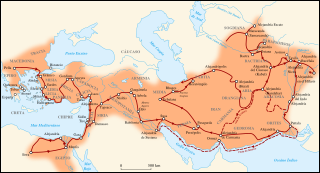
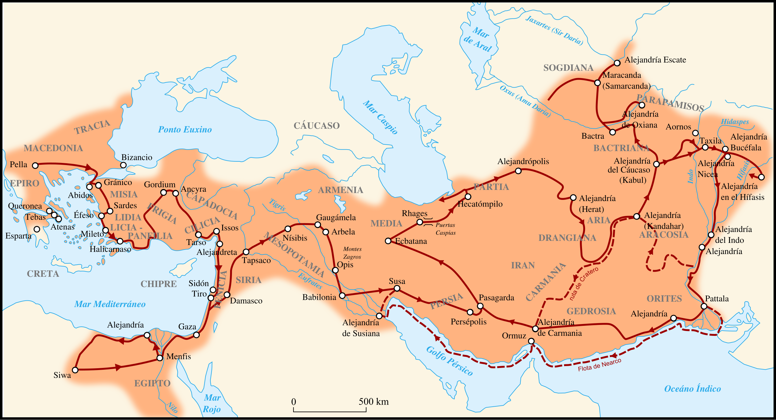
Español: Mapa del imperio macedónico durante el gobierno de Alejandro Magno incluyendo ruta de conquista
Français : Carte de l'Empire Macédonien sous Alexandre III "Le Grand" dans l'Antiquité
English: Map of Macedonian Empire under Alexander III "The Great" command in Antic period
Ελληνικά: Χάρτης της Μακεδονικής αυτοκρατορίας του Αλέξανδρου του Μέγα |
| Date | (UTC) |
| Source | |
| Author |
|
| Other versions |
 Arabic Arabic |


|
This SVG file contains embedded text that can be translated into your language, using any capable SVG editor, text editor or the SVG Translate tool. For more information see: About translating SVG files. |
This file is licensed under the Creative Commons Attribution-Share Alike 3.0 Unported license.
- You are free:
- to share – to copy, distribute and transmit the work
- to remix – to adapt the work
- Under the following conditions:
- attribution – You must give appropriate credit, provide a link to the license, and indicate if changes were made. You may do so in any reasonable manner, but not in any way that suggests the licensor endorses you or your use.
- share alike – If you remix, transform, or build upon the material, you must distribute your contributions under the same or compatible license as the original.
Original upload log[edit]
This image is a derivative work of the following images:
- File:MacedonEmpire.jpg licensed with Cc-by-sa-3.0-migrated, GFDL-GMT
- 2006-04-13T18:47:39Z Captain Blood 2000x961 (825270 Bytes) A. in Arachosia corr.
- 2006-03-24T17:38:35Z Captain Blood 2000x961 (825243 Bytes) {{GFDL-GMT}}
- File:Mapa_de_Alejandrías.svg licensed with Cc-by-sa-3.0
- 2009-09-26T00:17:57Z Mircalla22 1243x673 (204990 Bytes) {{Information |Description={{es}}Mapa del imperio macedónico durante el gobierno de Alejandro Magno. {{fr}}Carte de l'Empire Macédonien sous Alexandre III "Le Grand" dans l'Antiquité {{en}}Map of Macedonian Empire under A
Uploaded with derivativeFX
| Annotations | This image is annotated: View the annotations at Commons |
File history
Click on a date/time to view the file as it appeared at that time.
| Date/Time | Thumbnail | Dimensions | User | Comment | |
|---|---|---|---|---|---|
| current | 20:23, 7 November 2019 | | 1,243 × 673 (882 KB) | Rowanwindwhistler (talk | contribs) | Fake text to improve rendering (real text hidden) |
| 21:10, 10 October 2009 |  | 1,243 × 673 (289 KB) | Mircalla22 (talk | contribs) | difuminando fronteras | |
| 05:46, 8 October 2009 |  | 1,243 × 673 (289 KB) | Mircalla22 (talk | contribs) | Texto con problemas a trazo. | |
| 05:43, 8 October 2009 |  | 1,243 × 673 (262 KB) | Mircalla22 (talk | contribs) | {{Information |Description=== {{es}}Mapa del imperio macedónico durante el gobierno de Alejandro Magno incluyendo ruta de conquista {{fr}}Carte de l'Empire Macédonien sous Alexandre III "Le Grand" dans l'Antiquité {{en}}Map of Macedonian Empire unde |
You cannot overwrite this file.
File usage on Commons
The following 4 pages use this file:
File usage on other wikis
The following other wikis use this file:
- Usage on ast.wikipedia.org
- Usage on diq.wikipedia.org
- Usage on es.wikipedia.org
- Edad Antigua
- Reino de Macedonia
- Historia universal
- Historia de Uzbekistán
- Dinastía macedónica de Egipto
- Diádocos
- Guerra lamiaca
- Sucesión de Alejandro Magno
- Usuario:Alejandro Magno
- Wikiproyecto:Ilustración/Taller gráfico/Peticiones/Archivo 9
- Usuario:Spirit-Black-Wikipedista/Próximos3
- Incidente de la proskynesis
- Helenización
- Anexo:Imperios por superficie
- Pablo y el judaísmo
- Helenización (Edad Antigua)
- Usage on hu.wikipedia.org
- Usage on hy.wikipedia.org
- Usage on io.wikipedia.org
- Usage on pl.wikipedia.org
- Usage on tr.wikipedia.org