File:Hungary map 1941.png
Jump to navigation
Jump to search

Size of this preview: 800 × 578 pixels. Other resolutions: 320 × 231 pixels | 640 × 462 pixels | 1,022 × 738 pixels.
Original file (1,022 × 738 pixels, file size: 69 KB, MIME type: image/png)
Captions
Captions
Add a one-line explanation of what this file represents
Summary[edit]
| Description |
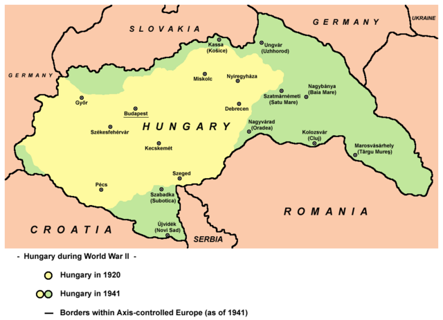
English: Hungary in 1920 and in 1941. |
| Date | |
| Source | Own work |
| Author | User:PANONIAN |
| Other versions |
Derivative works of this file: |
References[edit]
- The Times History of Europe, Times Books, London, 2002.
- Richard Overy, The Times History of the 20th Century, Times Books, London, 2004.
- Peter Rokai - Zoltan Đere - Tibor Pal - Aleksandar Kasaš, Istorija Mađara, Beograd, 2002.
- http://terkepek.adatbank.transindex.ro/kepek/netre/224.gif
- http://www.hunmagyar.org/tor/terkep.jpg
- http://www.map.hu/galeria/orig/1426_hu_in_maps_fig_12_states_1648-2009.jpg archive copy at the Wayback Machine
Licensing[edit]
| This work has been released into the public domain by its author, PANONIAN. This applies worldwide. In some countries this may not be legally possible; if so: |

|
This map has been uploaded by Electionworld from en.wikipedia.org to enable the |
File history
Click on a date/time to view the file as it appeared at that time.
| Date/Time | Thumbnail | Dimensions | User | Comment | |
|---|---|---|---|---|---|
| current | 19:22, 11 February 2014 | | 1,022 × 738 (69 KB) | PANONIAN (talk | contribs) | aesthetics, corrections |
| 10:43, 11 July 2010 |  | 1,023 × 738 (69 KB) | PANONIAN (talk | contribs) | Reverted to version as of 19:28, 16 December 2009 - please upload your map as separate file, not over this one | |
| 16:43, 9 July 2010 |  | 1,023 × 738 (60 KB) | Mix321 (talk | contribs) | drobne | |
| 19:28, 16 December 2009 |  | 1,023 × 738 (69 KB) | PANONIAN (talk | contribs) | Reverted to version as of 19:23, 16 December 2009 - fixing thumbnail problem | |
| 19:26, 16 December 2009 |  | 800 × 540 (16 KB) | PANONIAN (talk | contribs) | Reverted to version as of 23:57, 23 December 2006 - fixing thumbnail problem | |
| 19:23, 16 December 2009 |  | 1,023 × 738 (69 KB) | PANONIAN (talk | contribs) | improved version | |
| 23:57, 23 December 2006 |  | 800 × 540 (16 KB) | Electionworld (talk | contribs) | {{ew|en|PANONIAN}} == Licensing == {{PD-user|PANONIAN}} Category:Maps of the history of Hungary Category:Maps of the history of Romania |
You cannot overwrite this file.
File usage on Commons
The following 15 pages use this file:
File usage on other wikis
The following other wikis use this file:
- Usage on ar.wikipedia.org
- Usage on ast.wikipedia.org
- Usage on ba.wikipedia.org
- Usage on be.wikipedia.org
- Usage on bg.wikipedia.org
- Usage on bs.wikipedia.org
- Usage on ca.wikipedia.org
- Usage on cs.wikipedia.org
- Usage on cv.wikipedia.org
- Usage on en.wikipedia.org
- Usage on eo.wikipedia.org
- Usage on fo.wikipedia.org
- Usage on fr.wikipedia.org
- Usage on gl.wikipedia.org
- Usage on he.wikipedia.org
- Usage on hr.wikipedia.org
- Usage on hu.wikipedia.org
- Usage on is.wikipedia.org
- Usage on it.wikipedia.org
- Usage on ja.wikipedia.org
- Usage on jv.wikipedia.org
- Usage on ko.wikipedia.org
- Usage on lt.wikipedia.org
- Usage on nl.wikipedia.org
- Usage on pl.wikipedia.org
- Usage on pt.wikipedia.org
- Usage on ro.wikipedia.org
View more global usage of this file.