File:Heatwave in western Europe ESA24321812.jpeg

Original file (1,920 × 2,560 pixels, file size: 4.58 MB, MIME type: image/jpeg)
Captions
Captions
Summary
[edit]
| Description |
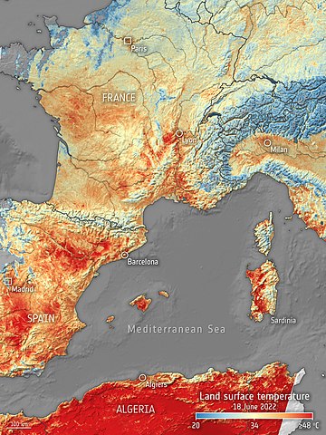
English: An intense, early heatwave is baking western Europe, with temperatures in many places topping 40°C on Saturday 18 June. This image, produced using data from the Copernicus Sentinel-3 mission, shows the land surface temperature across western Europe and part of Algeria. The map was generated by using the mission’s Sea and Land Surface Temperature Radiometer instrument. While weather forecasts use predicted air temperatures, this satellite instrument measures the real amount of energy radiating from Earth. Therefore, the map shows the actual temperature of the land’s surface pictured here, which is usually significantly hotter than air temperatures. The Sentinel-3 mission was able to obtain an accurate measurement of the land surface temperature of the ground, which exceeded 50°C in many areas, especially in Spain. For more information on the Copernicus Sentinel-3 mission, click here. |
| Date | 21 June 2022 (upload date) |
| Source | Heatwave in western Europe |
| Author | European Space Agency |
| Activity | Observing the Earth |
| Mission | Sentinel-3 |
| System | Copernicus |
Licensing
[edit]

|
This image contains data from a satellite in the Copernicus Programme, such as Sentinel-1, Sentinel-2 or Sentinel-3. Attribution is required when using this image.
Attribution: Contains modified Copernicus Sentinel data 2022
The use of Copernicus Sentinel Data is regulated under EU law (Commission Delegated Regulation (EU) No 1159/2013 and Regulation (EU) No 377/2014). Relevant excerpts:
Free access shall be given to GMES dedicated data [...] made available through GMES dissemination platforms [...].
Access to GMES dedicated data [...] shall be given for the purpose of the following use in so far as it is lawful:
GMES dedicated data [...] may be used worldwide without limitations in time.
GMES dedicated data and GMES service information are provided to users without any express or implied warranty, including as regards quality and suitability for any purpose. |
This media was created by the European Space Agency (ESA).
Where expressly so stated, images or videos are covered by the Creative Commons Attribution-ShareAlike 3.0 IGO (CC BY-SA 3.0 IGO) licence, ESA being an Intergovernmental Organisation (IGO), as defined by the CC BY-SA 3.0 IGO licence. The user is allowed under the terms and conditions of the CC BY-SA 3.0 IGO license to Reproduce, Distribute and Publicly Perform the ESA images and videos released under CC BY-SA 3.0 IGO licence and the Adaptations thereof, without further explicit permission being necessary, for as long as the user complies with the conditions and restrictions set forth in the CC BY-SA 3.0 IGO licence, these including that:
See the ESA Creative Commons copyright notice for complete information, and this article for additional details.
|
 | |
This file is licensed under the Creative Commons Attribution-ShareAlike 3.0 IGO license. Attribution: ESA, CC BY-SA IGO 3.0
| ||
File history
Click on a date/time to view the file as it appeared at that time.
| Date/Time | Thumbnail | Dimensions | User | Comment | |
|---|---|---|---|---|---|
| current | 12:33, 21 June 2022 | | 1,920 × 2,560 (4.58 MB) | OptimusPrimeBot (talk | contribs) | #Spacemedia - Upload of https://www.esa.int/var/esa/storage/images/esa_multimedia/images/2022/06/heatwave_in_western_europe/24321801-1-eng-GB/Heatwave_in_western_Europe.jpg via Commons:Spacemedia |
You cannot overwrite this file.
File usage on Commons
There are no pages that use this file.
File usage on other wikis
The following other wikis use this file:
- Usage on ar.wikipedia.org
- Usage on de.wikipedia.org
- Usage on en.wikipedia.org
- Usage on es.wikipedia.org
- Usage on fr.wikipedia.org