File:Geologic Map Lake Superior MN WI MI.jpg
Jump to navigation
Jump to search

Size of this preview: 800 × 540 pixels. Other resolutions: 320 × 216 pixels | 640 × 432 pixels | 1,024 × 691 pixels | 1,280 × 864 pixels | 2,560 × 1,728 pixels | 16,327 × 11,018 pixels.
Original file (16,327 × 11,018 pixels, file size: 35.93 MB, MIME type: image/jpeg)
Captions
Captions
Add a one-line explanation of what this file represents
| Warning | The original file is very high-resolution. It might not load properly or could cause your browser to freeze when opened at full size. |
|---|
| Description |
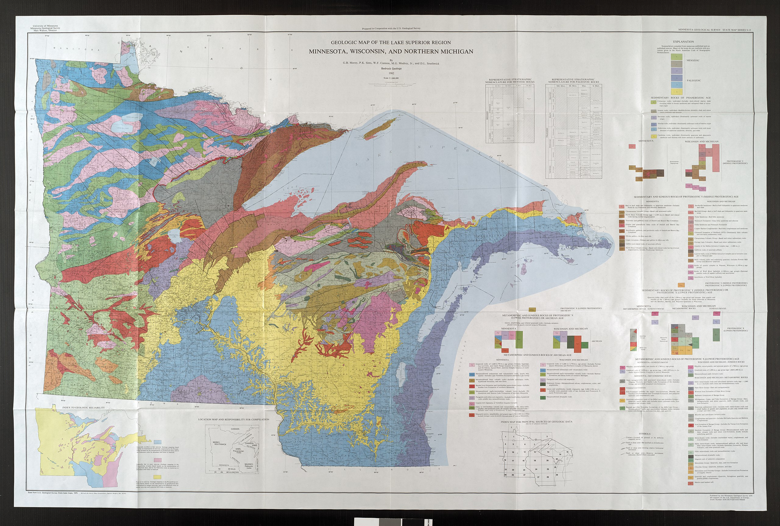
English: Bedrock geologic map of the US area bordering Lake Superior in Minnesota, Wisconsin, and Michigan. |
|||
| Date | ||||
| Source | Minnesota Geological Survey, University of Minnesota: ftp://mgssun6.mngs.umn.edu/map_catalog/jp2k/umn22628.jp2 | |||
| Author | Morey, G. B., Sims, P. K. Cannon, W. F., Mudrey, M. G., Jr., D. L. Southwick | |||
| Permission (Reusing this file) |
|
File history
Click on a date/time to view the file as it appeared at that time.
| Date/Time | Thumbnail | Dimensions | User | Comment | |
|---|---|---|---|---|---|
| current | 20:51, 14 March 2009 | | 16,327 × 11,018 (35.93 MB) | Awickert (talk | contribs) | {{Information |Description={{en|1=Bedrock geologic map of the US area bordering Lake Superior in Minnesota, Wisconsin, and Michigan.}} |Source=Minnesota Geological Survey, University of Minnesota: ftp://mgssun6.mngs.umn.edu/map_catalog/jp2k/umn22628.jp2 | |
You cannot overwrite this file.
File usage on Commons
The following page uses this file:
Metadata
Categories:
- Geological maps of Wisconsin
- Geological maps of Minnesota
- Geological maps of Michigan
- Maps of Lake Superior
- Stratigraphic columns of the United States
- Geology of Lake Superior
- Stratigraphic columns of Wisconsin
- Stratigraphic columns of Minnesota
- Stratigraphic columns of Michigan
- Niobrara Formation in Minnesota
- Carlile Shale Formation - maps
- Greenhorn Formation
- Colorado Group (geology) in Minnesota
- Windrow Formation
- Coleraine Formation
- Graneros Shale
- Dakota Formation in Minnesota
- Hallock Red Beds
- Niobrara Formation - maps
- Dakota Formation - maps
- Colorado Group (geology) - maps
- Niobrara Formation - stratigraphic columns
- Dakota Formation - stratigraphic columns
- Colorado Group (geology) - stratigraphic columns
- Cedar Valley Formation
- Red River Formation
- Winnipeg Formation
- Dubuque Formation
- Galena Group
- Decorah Formation
- Platteville Limestone
- Platteville Group - maps
- Platteville Group - stratigraphic columns
- Maquoketa Group - maps
- Maquoketa Group - stratigraphic columns
- Glenwood Formation
- St. Peter Sandstone in Minnesota
- St. Peter Sandstone - maps
- St. Peter Sandstone - stratigraphic columns
- Prairie du Chien Group - maps
- Prairie du Chien Group - stratigraphic columns
- Shakopee Formation - maps
- Oneota Formation
- Jordan Sandstone
- St. Lawrence Formation
- Franconia Formation (U.S. geology)
- Ionion Sandstone
- Galesville Sandstone
- Eau Claire Formation
- Keweenawan Supergroup
- Kenwood Shale
- Milwaukee Formation
- Thiensville Formation
- Lake Church Formation
- Waubakee Formation
- Racine Formation (geology)
- Manistique Formation
- Hendricks Formation
- Byron Formation
- Mayville Formation
- Neda Formation
- Mount Simon Sandstone
- St. Peter Sandstone in Wisconsin
- Lone Rock Formation
- Mazomanie Formation
- Wonewoc Formation
- Bonneterre Dolomite
- Bois Blanc Formation
- Salina Group (geology) - maps
- Engadine Dolomite (U.S. geology)
- Burnt Bluff Group
- Lime Island Dolomite
- Cataract Group
- Cabot Head Dolomite
- Manitoulin Formation
- Mormon Creek Formation
- Big Hill Formation
- Stonington Formation
- Bill's Creek Shale
- Trenton Group (U.S. geology)
- Groos Quarry Formation
- Chandler Falls Formation
- Black River Group (geology)
- Bony Falls Formation
- Trempealeau Formation
- Munising Formation