File:Gdansk Bay Borderlines 1939 greek.png
Jump to navigation
Jump to search

Size of this preview: 800 × 517 pixels. Other resolutions: 320 × 207 pixels | 640 × 414 pixels | 1,024 × 662 pixels | 1,339 × 866 pixels.
Original file (1,339 × 866 pixels, file size: 93 KB, MIME type: image/png)
Captions
Captions
Add a one-line explanation of what this file represents
Summary[edit]
| Description |
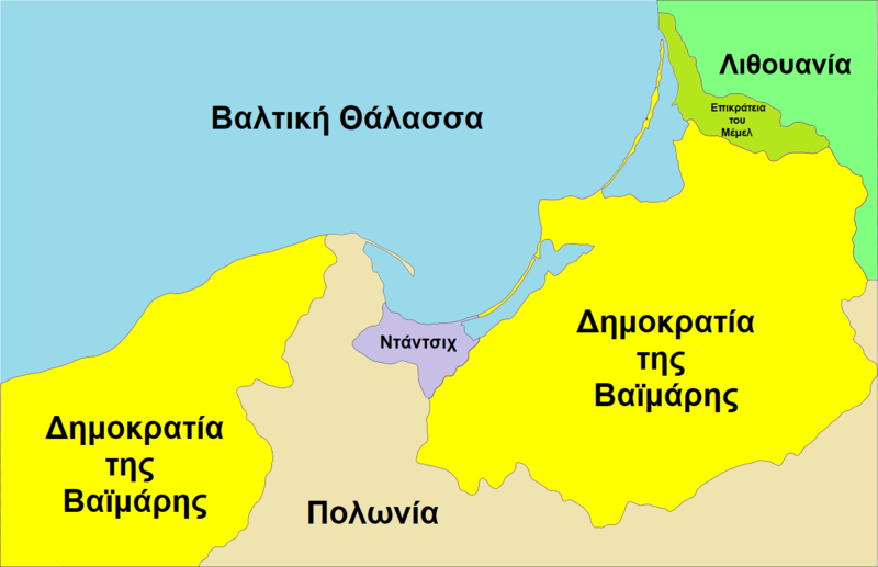
English: Map of the Gdańsk Bay in 1939. The Memel Territory was retransfered from Lithuania to Germany in March
1939. Deutsch: Karte der Danziger Bucht mit den Grenzen von 1939. Das Memelland ging im März 1939 von Litauen zurück an das Deutsche Reich Ελληνικά: Χάρτης των συνόρων της ελεύθερης πόλης του Ντάντσιχ στα ελληνικά. Οι διαφορές στα χρώματα/γραμματοσειρά οφείλονται λόγω της χρήσης του Microsoft Paint. |
| Date | |
| Source | File:Gdansk Bay Borderlines 1939 English.svg |
| Author |
|
| Other versions |
[]
|


Licensing[edit]
This file is licensed under the Creative Commons Attribution 3.0 Unported license.
- You are free:
- to share – to copy, distribute and transmit the work
- to remix – to adapt the work
- Under the following conditions:
- attribution – You must give appropriate credit, provide a link to the license, and indicate if changes were made. You may do so in any reasonable manner, but not in any way that suggests the licensor endorses you or your use.
File history
Click on a date/time to view the file as it appeared at that time.
| Date/Time | Thumbnail | Dimensions | User | Comment | |
|---|---|---|---|---|---|
| current | 00:49, 4 September 2019 | | 1,339 × 866 (93 KB) | NikosLikomitros (talk | contribs) | {{Πληροφορίες εικόνας |Περιγραφή=Χάρτης των συνόρων της ελεύθερης πόλης του Ντάντσιχ στα ελληνικά. |Πηγή=File:Gdansk Bay Borderlines 1939 English.svg, αρχείο πηγής. |Ημερομηνία=4 Σεπτεμβρίου 2019 (μετάφραση) |Δημιουργός=Justass, μετάφραση από Nikosgranturismogt. Οι διαφορές στα χρώματα/γραμματοσειρά οφείλονται λόγω της χρήσης του Microsoft Paint. |Άδεια χρήσης= }} |
You cannot overwrite this file.
File usage on Commons
The following 18 pages use this file:
- User:NikosLikomitros/Work
- File:Danzig 1919–1939-ar.svg
- File:Danzig Bay Borderlines 1939 Hebrew.jpg
- File:Danzig Bay Borderlines 1939 Hebrew Danzig.jpg
- File:Danzigi linnriigi asukoht.jpg
- File:Gdansk Bay Borderlines 1939-hu.svg
- File:Gdansk Bay Borderlines 1939 Chinese.svg
- File:Gdansk Bay Borderlines 1939 English.svg
- File:Gdansk Bay Borderlines 1939 Esperanto.svg
- File:Gdansk Bay Borderlines 1939 Français.svg
- File:Gdansk Bay Borderlines 1939 German.png
- File:Gdansk Bay Borderlines 1939 Polish.png
- File:Gdansk Bay Borderlines 1939 Welsh.svg
- File:Gdansk Bay Borderlines 1939 blank.png
- File:Gdansk Bay Borderlines 1939 greek.png
- File:Gdansk Bay Borderlines 1939 ko.svg
- File:Gdansk Bay Details 1939 english.PNG
- Template:Other versions/Gdansk Bay Borderlines
File usage on other wikis
The following other wikis use this file:
- Usage on el.wikipedia.org