File:Garzweiler surface mine, October 2018, -01.jpg
Jump to navigation
Jump to search
Size of this preview: 800 × 427 pixels. Other resolutions: 320 × 171 pixels | 640 × 342 pixels | 1,024 × 547 pixels | 1,280 × 684 pixels | 2,560 × 1,368 pixels | 5,105 × 2,727 pixels.
Original file (5,105 × 2,727 pixels, file size: 12.09 MB, MIME type: image/jpeg)
Captions
Captions
Add a one-line explanation of what this file represents
Summary[edit]
| Description |
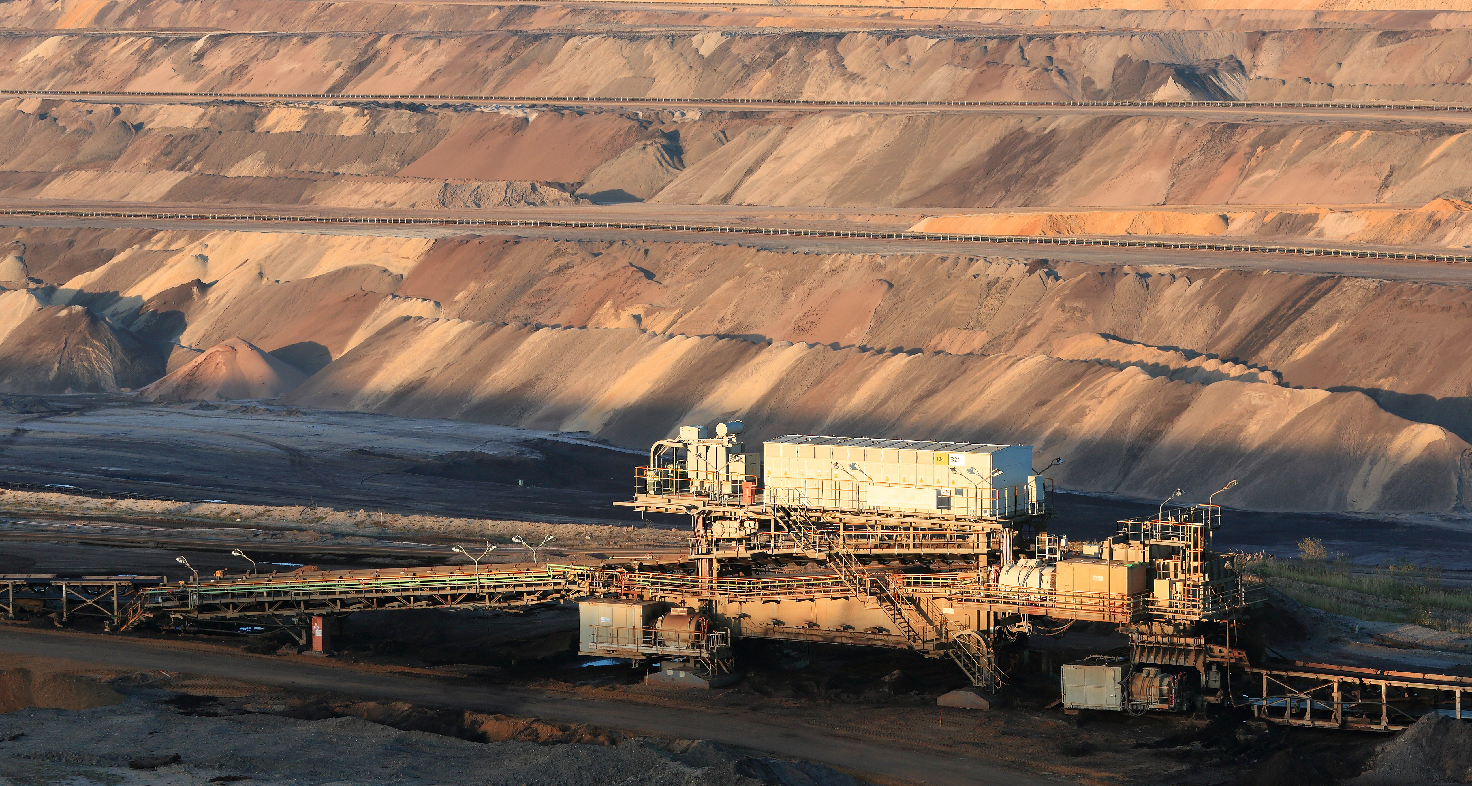
English: The Tagebau Garzweiler is a surface mine in the German state of North Rhine-Westphalia. It is operated by RWE and used for mining lignite.
Español: Tagebau Garzweiler es una mina a cielo abierto en el estado alemán de Renania del Norte-Westfalia. La mina es operada por RWE y se utiliza para extraer lignito.
Čeština: Povrchový důl Tagebau Garzweiler na těžbu hnědého uhlí společnosti RWE v německém Severním Porýní-Vestfálsku.
Français : La mine à ciel ouvert de Garzweiler (Allemagne), site d'extraction de lignite opéré par le conglomérat RWE.
Magyar: A Tagebau Garzweiler egy külszíni fejtésű bánya. Az RWE üzemelteti, és lignitet bányásznak belőle (Észak-Rajna-Vesztfália Németország)
Македонски: Рудникот за лигнит „Гарцвајлер“ во Северна Рајна-Вестфалија, Германија.
Português: Tagebau Garzweiler é uma mina a céu aberto no estado alemão da Renânia do Norte-Vestfália. A mina é operada pela RWE e utilizada na extração do lignito
Эрзянь: Тагебау Гарцвайлер — те панжадо таргамо тарка немецень Пелевеёнкс Рейн-Вестфалия штатсонть. Тевтнень вети RWE ды сынь тесэ таргить тюжа седь.
Українська: «Карьер Гарцвейлер» — кар'єрна копальня в німецькій землі Північний Рейн-Вестфалія. Вона знаходиться у віданні RWE і використовується для видобутку бурого вугілля. |
|||||||||||||||||
| Date | ||||||||||||||||||
| Source | Own work | |||||||||||||||||
| Author |
|
|||||||||||||||||

| Camera location | | View this and other nearby images on: OpenStreetMap |
|---|
Assessment[edit]
|
This image was selected as picture of the day on Wikimedia Commons for 2 November 2020. It was captioned as follows: English: Tagebau Garzweiler is a surface mine in the German state of North-Rhine Westphalia. It is operated by RWE and used for mining lignite. Other languages:
Čeština: Povrchový důl Tagebau Garzweiler na těžbu hnědého uhlí společnosti RWE v německém Severním Porýní-Vestfálsku. English: Tagebau Garzweiler is a surface mine in the German state of North-Rhine Westphalia. It is operated by RWE and used for mining lignite. Español: Tagebau Garzweiler es una mina a cielo abierto en el estado alemán de Renania del Norte-Westfalia. La mina es operada por RWE y se utiliza para extraer lignito. Français : La mine à ciel ouvert de Garzweiler (Allemagne), site d'extraction de lignite opéré par le conglomérat RWE. Magyar: A Tagebau Garzweiler külszíni fejtésű bánya. Az RWE üzemelteti, és lignitet bányásznak belőle (Észak-Rajna-Vesztfália Németország) Português: Tagebau Garzweiler é uma mina a céu aberto no estado alemão da Renânia do Norte-Vestfália. A mina é operada pela RWE e utilizada na extração do lignito Македонски: Рудникот за лигнит „Гарцвајлер“ во Северна Рајна-Вестфалија, Германија. Українська: «Карьер Гарцвейлер» — кар'єрна копальня в німецькій землі Північний Рейн-Вестфалія. Вона знаходиться у віданні RWE і використовується для видобутку бурого вугілля. |
Licensing[edit]
I, the copyright holder of this work, hereby publish it under the following license:
This file is licensed under the Creative Commons Attribution-Share Alike 4.0 International license.
- You are free:
- to share – to copy, distribute and transmit the work
- to remix – to adapt the work
- Under the following conditions:
- attribution – You must give appropriate credit, provide a link to the license, and indicate if changes were made. You may do so in any reasonable manner, but not in any way that suggests the licensor endorses you or your use.
- share alike – If you remix, transform, or build upon the material, you must distribute your contributions under the same or compatible license as the original.
File history
Click on a date/time to view the file as it appeared at that time.
| Date/Time | Thumbnail | Dimensions | User | Comment | |
|---|---|---|---|---|---|
| current | 11:46, 23 October 2018 | | 5,105 × 2,727 (12.09 MB) | Martin Falbisoner (talk | contribs) | crop |
| 11:54, 14 October 2018 |  | 5,105 × 3,128 (13.72 MB) | Martin Falbisoner (talk | contribs) | User created page with UploadWizard |
You cannot overwrite this file.
File usage on Commons
The following 30 pages use this file:
- User:Eatcha/POTY-2018-Round-1-Results
- User:Martin Falbisoner
- User:Nardog/PotY
- User talk:Martin Falbisoner/Archive 6 2018
- User talk:Martin Falbisoner/Archive 8 2020
- Commons:Featured picture candidates/File:Garzweiler surface mine, October 2018, -01.jpg
- Commons:Featured picture candidates/Log/October 2018
- Commons:Featured pictures/Places/Industry
- Commons:Featured pictures/chronological/2018-B
- Commons:Picture of the Year/2018/Candidates
- Commons:Picture of the Year/2018/R1/Gallery/2018-B
- Commons:Picture of the Year/2018/R1/Gallery/ALL
- Commons:Picture of the Year/2018/R1/Gallery/Infrastructure
- Commons:Picture of the Year/2018/R1/Gallery/M10
- Commons:Picture of the Year/2018/R1/v/Garzweiler surface mine, October 2018, -01.jpg
- Commons:Quality images/Subject/Objects/Industrial/Archive 2016-2019
- Commons:Quality images candidates/Archives October 17 2018
- Template:Potd/2020-11
- Template:Potd/2020-11-02
- Template:Potd/2020-11-02 (cs)
- Template:Potd/2020-11-02 (en)
- Template:Potd/2020-11-02 (es)
- Template:Potd/2020-11-02 (fr)
- Template:Potd/2020-11-02 (hu)
- Template:Potd/2020-11-02 (mk)
- Template:Potd/2020-11-02 (myv)
- Template:Potd/2020-11-02 (nl)
- Template:Potd/2020-11-02 (pt)
- Template:Potd/2020-11-02 (pt-br)
- Template:Potd/2020-11-02 (uk)
File usage on other wikis
The following other wikis use this file:
- Usage on av.wikipedia.org
- Usage on be-tarask.wikipedia.org
- Usage on crh.wikipedia.org
- Usage on cv.wikipedia.org
- Usage on de.wikipedia.org
- Usage on en.wikipedia.org
- Usage on fr.wikipedia.org
- Usage on hu.wikipedia.org
- Usage on hy.wikipedia.org
- Usage on ka.wikipedia.org
- Usage on ko.wikipedia.org
- Usage on lbe.wikipedia.org
- Usage on lez.wikipedia.org
- Usage on li.wikipedia.org
- Usage on mk.wikipedia.org
- Usage on os.wikipedia.org
- Usage on pt.wikipedia.org
- Usage on ru.wikipedia.org
- Usage on ru.wikinews.org
- Usage on sah.wikipedia.org
- Usage on sr.wikipedia.org
- Usage on tt.wikipedia.org
- Usage on vep.wikipedia.org
- Usage on zh.wikipedia.org