File:Falkland Islands map.svg
Jump to navigation
Jump to search

Size of this PNG preview of this SVG file: 769 × 600 pixels. Other resolutions: 308 × 240 pixels | 616 × 480 pixels | 985 × 768 pixels | 1,280 × 998 pixels | 2,560 × 1,996 pixels | 1,090 × 850 pixels.
Original file (SVG file, nominally 1,090 × 850 pixels, file size: 583 KB)
Captions
Captions
Add a one-line explanation of what this file represents

|
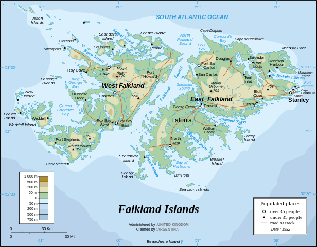
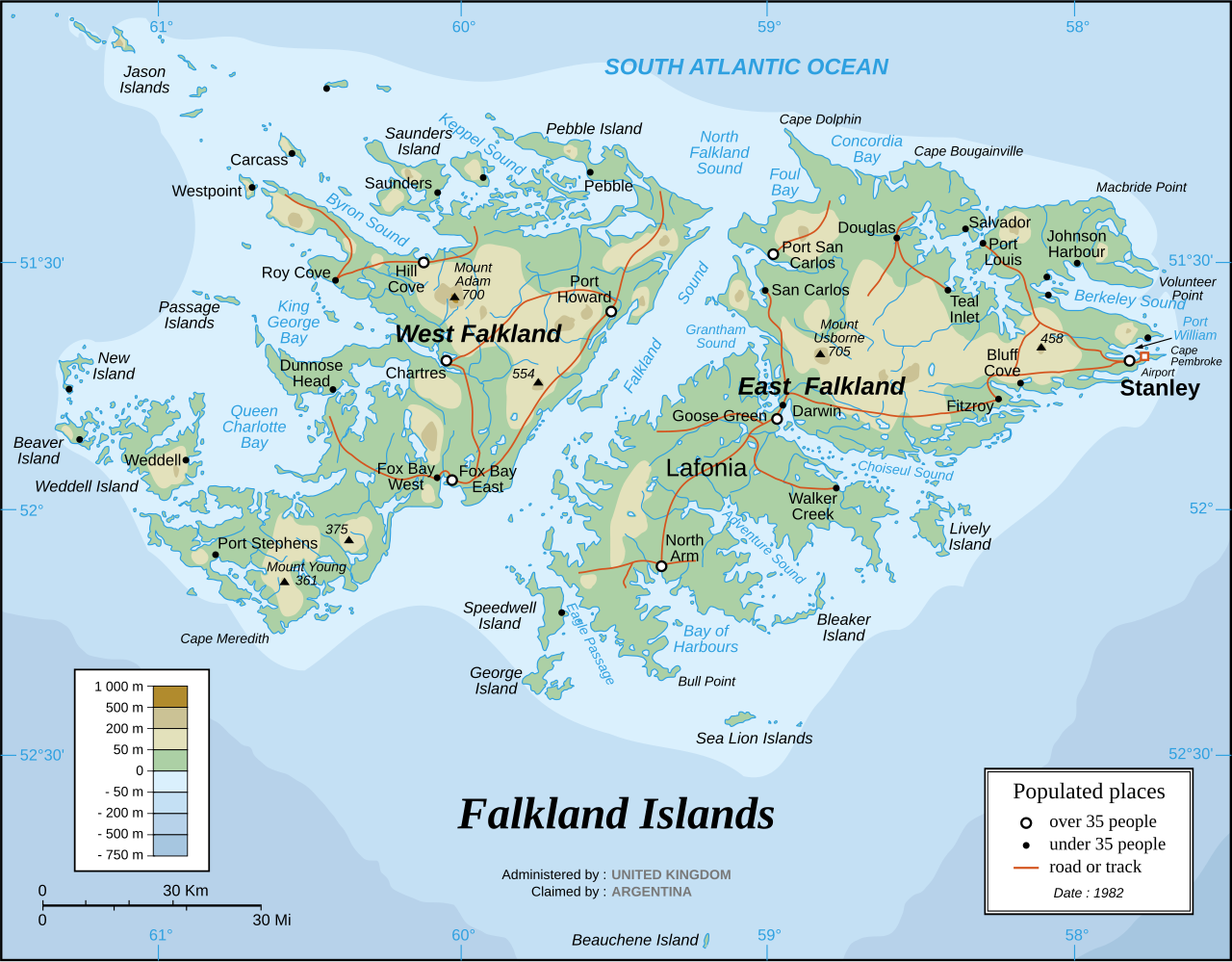
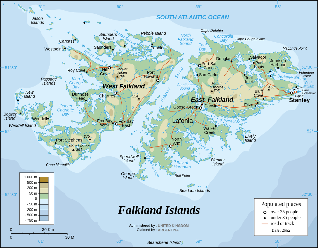
This file has been superseded by Falkland Islands topographic map-en.svg. It is recommended to use the other file. Please note that deleting superseded images requires consent. Reason to use the other file: "More precise map; created from NASA's digital elevation model"
|

|
Summary[edit]
| Description |
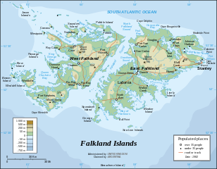
English: The Falkland Islands are an archipelago in the South Atlantic Ocean, located 300 miles off the coast of Argentina. They consist of two main islands, East Falkland and West Falkland, together with about 700 smaller islands. Stanley, on East Falkland, is the capital and largest city. The islands are a self-governing Overseas Territory of the United Kingdom, but have been the subject of a claim to sovereignty by Argentina since the British invasion of 1833.
Français : Carte en anglais des îles Malouines |
| Date | |
| Source |
Own work Background and elevation reference maps : Microsoft Encarta atlas (1999 edition) and UK government map 1982 demographic data : CIA map available on the site of the University of Texas at Austin |
| Author | Eric Gaba (Sting) |
| Other versions | in French: Iles Malouines carte.svg |
| SVG development |
Français :
- Sujet : Carte en anglais des îles Malouines ;
- Sources : Création personnelle
- Fond de carte et relief basés sur : atlas Encarta de Microsoft (édition 1999) et carte du gouvernement britannique ;
- Données démographiques de 1982 : carte de la CIA disponible sur la site de l'Université du Texas à Austin ;
- Auteur : Eric Gaba (fr:Sting) ;
- Date : Septembre 2006.
- Autre version : francophone : Image:Iles_Malouines_carte.svg
Licensing[edit]
I, the copyright holder of this work, hereby publish it under the following license:
This file is licensed under the Creative Commons Attribution-Share Alike 2.5 Generic license.
- You are free:
- to share – to copy, distribute and transmit the work
- to remix – to adapt the work
- Under the following conditions:
- attribution – You must give appropriate credit, provide a link to the license, and indicate if changes were made. You may do so in any reasonable manner, but not in any way that suggests the licensor endorses you or your use.
- share alike – If you remix, transform, or build upon the material, you must distribute your contributions under the same or compatible license as the original.
File history
Click on a date/time to view the file as it appeared at that time.
| Date/Time | Thumbnail | Dimensions | User | Comment | |
|---|---|---|---|---|---|
| current | 20:06, 31 March 2007 | | 1,090 × 850 (583 KB) | Sting (talk | contribs) | Some text corrections |
| 02:58, 28 September 2006 |  | 1,090 × 850 (586 KB) | Sting (talk | contribs) | Cosmetic correction | |
| 02:48, 28 September 2006 |  | 1,090 × 850 (586 KB) | Sting (talk | contribs) | {{Information |Description=Map of the Falkland Islands |Source=1982 demographic data : [http://www.lib.utexas.edu/maps/americas/falkland_islands.gif CIA map] available on the site of the [http://www.lib.utexas.edu/maps/americas.html#F University of Texas |
You cannot overwrite this file.
File usage on Commons
The following 2 pages use this file:
File usage on other wikis
The following other wikis use this file:
- Usage on azb.wikipedia.org
- Usage on de.wikipedia.org
- Usage on en.wikipedia.org
- Usage on es.wikinews.org
- Usage on gd.wikipedia.org
- Usage on he.wikipedia.org
- Usage on it.wikipedia.org
- Usage on ja.wikipedia.org
- Usage on lt.wikipedia.org
- Usage on no.wikipedia.org
- Usage on ro.wikipedia.org
- Usage on sr.wikipedia.org
- Usage on wuu.wikipedia.org