File:Eratosthenes measure of Earth circumference.svg
Jump to navigation
Jump to search

Size of this PNG preview of this SVG file: 512 × 341 pixels. Other resolutions: 320 × 213 pixels | 640 × 426 pixels | 1,024 × 682 pixels | 1,280 × 853 pixels | 2,560 × 1,705 pixels.
Original file (SVG file, nominally 512 × 341 pixels, file size: 54 KB)
Captions
Captions
Add a one-line explanation of what this file represents
Summary[edit]
| Description |
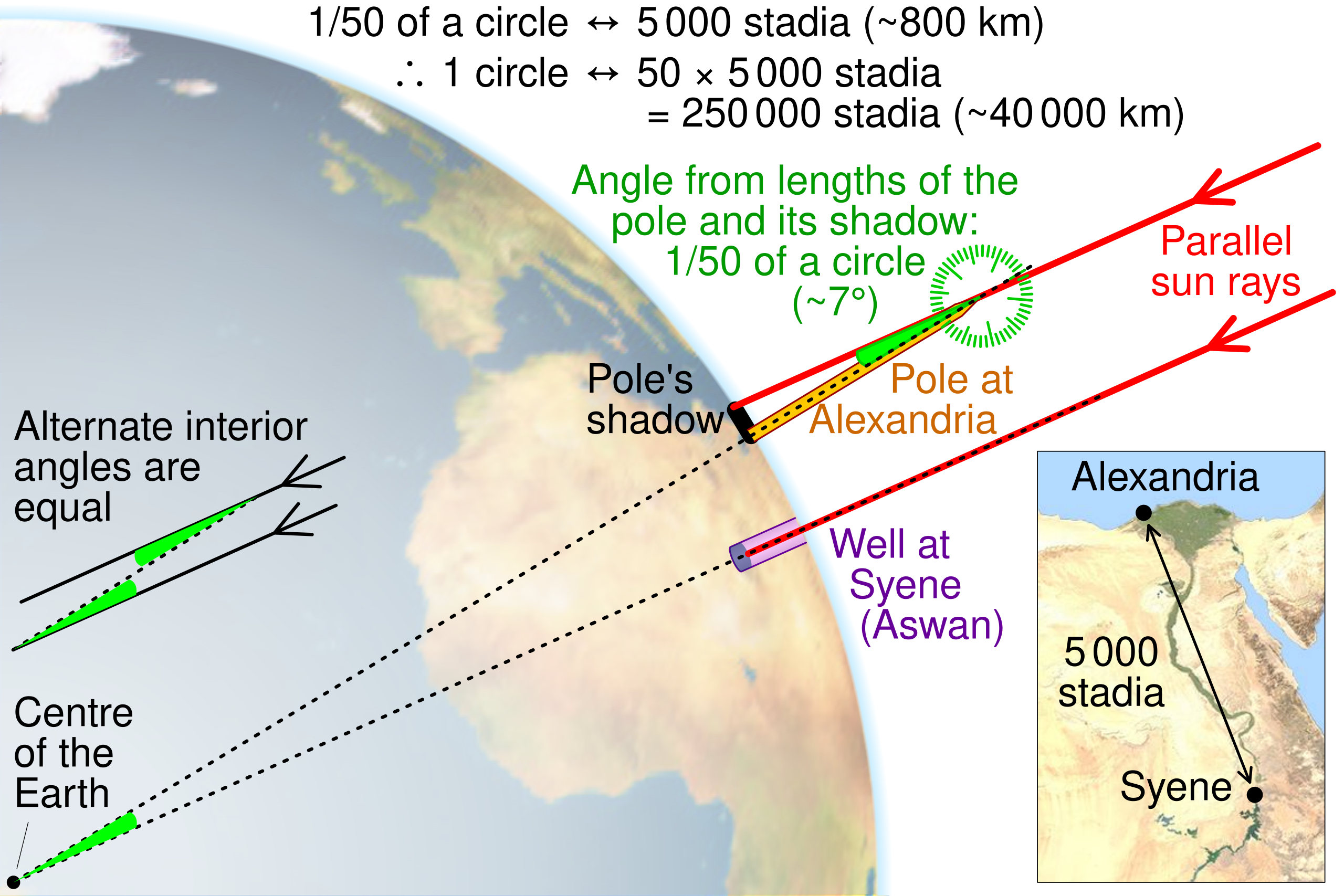
English: Illustration of the method Eratosthenes used to calculate the circumference of the Earth by CMG Lee. The map and globe are derived from http://commons.wikimedia.org/wiki/File:Egypt_sat.png and http://commons.wikimedia.org/wiki/File:Earth_orthographic_projection_Earthmap1000x500.jpg , respectively. |
||
| Date | |||
| Source |
|
||
| Author | cmglee, David Monniaux, jimht at shaw dot ca |


Licensing[edit]
This file is licensed under the Creative Commons Attribution-Share Alike 4.0 International license.
- You are free:
- to share – to copy, distribute and transmit the work
- to remix – to adapt the work
- Under the following conditions:
- attribution – You must give appropriate credit, provide a link to the license, and indicate if changes were made. You may do so in any reasonable manner, but not in any way that suggests the licensor endorses you or your use.
- share alike – If you remix, transform, or build upon the material, you must distribute your contributions under the same or compatible license as the original.
File history
Click on a date/time to view the file as it appeared at that time.
| Date/Time | Thumbnail | Dimensions | User | Comment | |
|---|---|---|---|---|---|
| current | 09:20, 15 February 2023 | | 512 × 341 (54 KB) | Getsnoopy (talk | contribs) | Fixed some formatting issues. |
| 10:11, 28 June 2022 |  | 512 × 341 (54 KB) | Andrei Stroe (talk | contribs) | File uploaded using svgtranslate tool (https://svgtranslate.toolforge.org/). Added translation for ro. | |
| 12:59, 9 October 2019 |  | 512 × 341 (50 KB) | Cmglee (talk | contribs) | Explain how shadow angle maps to angle around Earth centre. | |
| 19:30, 1 November 2016 |  | 512 × 341 (49 KB) | Cmglee (talk | contribs) | Use satellite photo instead of topo map, and add protractor. | |
| 00:34, 1 November 2016 |  | 512 × 341 (48 KB) | Cmglee (talk | contribs) | Outline shapes to work around thumbnail rendering bug losing gradient. | |
| 00:26, 1 November 2016 |  | 512 × 341 (49 KB) | Cmglee (talk | contribs) | User created page with UploadWizard |
You cannot overwrite this file.
File usage on Commons
The following 2 pages use this file:
File usage on other wikis
The following other wikis use this file:
- Usage on bs.wikipedia.org
- Usage on ca.wikipedia.org
- Usage on el.wikipedia.org
- Usage on en.wikipedia.org
- Usage on es.wikipedia.org
- Usage on hi.wikipedia.org
- Usage on hu.wikipedia.org
- Usage on id.wikipedia.org
- Usage on incubator.wikimedia.org
- Usage on ja.wikipedia.org
- Usage on ms.wikipedia.org
- Usage on nl.wikipedia.org
- Usage on pt.wikipedia.org
- Usage on ro.wikipedia.org
- Usage on sd.wikipedia.org
- Usage on simple.wikipedia.org
- Usage on sr.wikipedia.org
- Usage on th.wikipedia.org
- Usage on tr.wikipedia.org
- Usage on uk.wikipedia.org
- Usage on vi.wikipedia.org
- Usage on zh.wikipedia.org