File:Earth from Space- Namibian landforms ESA496928.jpg

Original file (4,954 × 5,370 pixels, file size: 35.42 MB, MIME type: image/jpeg)
Captions
Captions
Summary[edit]
| Description |
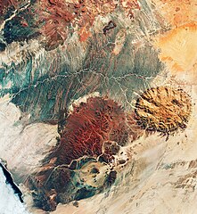
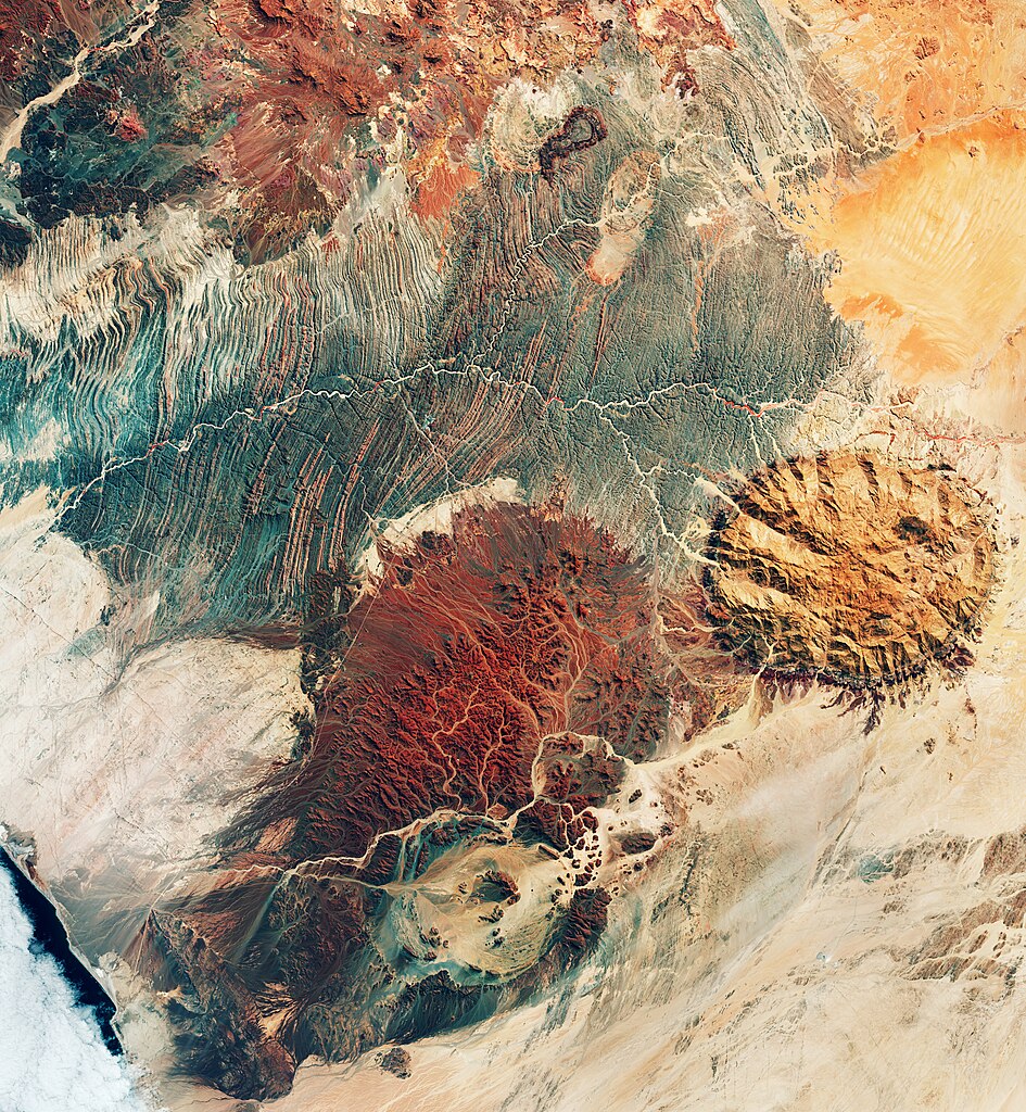
English: This image may resemble the surface of Mars, but it was actually captured by the Copernicus Sentinel-2 mission, revealing the stunning terrain of northwest Namibia. Zoom in to explore this image at its full 10 m resolution or click on the circles to learn more. The area pictured here includes part of the Kunene and Erongo regions, two of Namibia’s 13 regions. The Ugab River, visible as a winding, white line cutting through the centre of the image, clearly marks the border between Kunene (to the north) and Erongo. This false-colour image was taken in April 2024 and Copernicus Sentinel-2’s near-infrared channel was used to highlight the sparse vegetation of this extremely arid, desert landscape. Red patches of vegetation are discernible along the Ugab’s main course. The Ugab is ephemeral, only flowing above the surface of its sandy bed a few days each year. However, its subterranean water serves as an important resource for diverse wildlife, including the rare desert elephant. Namibia is renowned not only for its spectacular landscape, but also for offering clues to the history of tectonic plate movement in this part of Africa. Several significant geological features dominate this image. The circular, light brown formation on the right stands out from the surrounding plane; it is the Brandberg Massif, a granite mountain and, reaching 2500 m, one of the highest points in Namibia. It originated during the Early Cretaceous rifting that led to the opening of the South Atlantic Ocean. In the Ugab River valley, the impressive outcrop visible in shades of blue is the Zerrissene turbidite system, comprising folded, sedimentary rocks and spanning nearly 2700 sq km. The ring-shaped rim of the Messum Crater can be seen in the bottom centre of the image. Contrary to its appearance, the crater was not formed by a meteorite or asteroid impact, rather it’s part of a collapsed volcano. With a diameter of more than 20 km, it consists of two concentric circles of hills surrounding a wide, flat basin. Human presence in the area is minimal. Straight, white lines cutting across the landscape are roads, a subtle reminder that this region is not entirely unpopulated. |
| Date | 3 May 2024 (upload date) |
| Source | Earth from Space: Namibian landforms |
| Author | European Space Agency |
| Other versions |
|
| Activity | Observing the Earth |
| Mission | Sentinel-2 |
| Set | Earth from Space image collection |
| System | Copernicus |

Licensing[edit]

|
This image contains data from a satellite in the Copernicus Programme, such as Sentinel-1, Sentinel-2 or Sentinel-3. Attribution is required when using this image.
Attribution: Contains modified Copernicus Sentinel data 2024
The use of Copernicus Sentinel Data is regulated under EU law (Commission Delegated Regulation (EU) No 1159/2013 and Regulation (EU) No 377/2014). Relevant excerpts:
Free access shall be given to GMES dedicated data [...] made available through GMES dissemination platforms [...].
Access to GMES dedicated data [...] shall be given for the purpose of the following use in so far as it is lawful:
GMES dedicated data [...] may be used worldwide without limitations in time.
GMES dedicated data and GMES service information are provided to users without any express or implied warranty, including as regards quality and suitability for any purpose. |
This media was created by the European Space Agency (ESA).
Where expressly so stated, images or videos are covered by the Creative Commons Attribution-ShareAlike 3.0 IGO (CC BY-SA 3.0 IGO) licence, ESA being an Intergovernmental Organisation (IGO), as defined by the CC BY-SA 3.0 IGO licence. The user is allowed under the terms and conditions of the CC BY-SA 3.0 IGO license to Reproduce, Distribute and Publicly Perform the ESA images and videos released under CC BY-SA 3.0 IGO licence and the Adaptations thereof, without further explicit permission being necessary, for as long as the user complies with the conditions and restrictions set forth in the CC BY-SA 3.0 IGO licence, these including that:
See the ESA Creative Commons copyright notice for complete information, and this article for additional details.
|
 | |
This file is licensed under the Creative Commons Attribution-ShareAlike 3.0 IGO license. Attribution: ESA, CC BY-SA IGO 3.0
| ||
File history
Click on a date/time to view the file as it appeared at that time.
| Date/Time | Thumbnail | Dimensions | User | Comment | |
|---|---|---|---|---|---|
| current | 06:02, 4 May 2024 | | 4,954 × 5,370 (35.42 MB) | OptimusPrimeBot (talk | contribs) | #Spacemedia - Upload of https://www.esa.int/var/esa/storage/images/esa_multimedia/images/2024/05/earth_from_space_namibian_landforms/26062594-1-eng-GB/Earth_from_Space_Namibian_landforms.jpg via Commons:Spacemedia |
You cannot overwrite this file.
File usage on Commons
The following page uses this file: