File:Earth from Space- Bolivian salt lakes ESA497142.jpg

Original file (3,902 × 3,788 pixels, file size: 3.54 MB, MIME type: image/jpeg)
Captions
Captions
Summary[edit]
| Description |
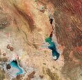
English: This Copernicus Sentinel-2 image features salt flats and lakes in southwest Bolivia, near the crest of the Andes Mountains. Zoom in to explore this image at its full resolution or click on the circles to learn more. Acquired in April 2024, this false-colour image shows part of the Oruro Department towards the southern end of the Altiplano, a high plain that stretches almost 1000 km from Peru to Bolivia. The image was processed using the near-infrared channel which highlights vegetation in red. As seen in the image, this part of the Altiplano is mostly arid with saline soils. Some 40 000 years ago, this area was part of a giant lake that dried up, leaving behind two salt flats: Uyuni (not pictured) and Coipasa, visible in grey and light blue in the bottom-left corner. It also left behind two lakes: Poopó, the larger water body near the centre of the image, and Uru Uru, just above Poopó. Lake Poopó is a saline lake and covers approximately 1000 sq km. It is an endorheic basin, which means water is lost through evaporation. However, the lake’s shallow nature, with an average depth of just 3 m, has made its water level very sensitive to fluctuations. This is clear to see in the image, as part of the lakebed surrounding the water appears grey and dry. In the last decades, the lake has fully evaporated on some occasions, with catastrophic consequences for the region’s flora and fauna and for the economy. The lake’s main tributary, the Desaguadero River, is visible north of the lake, dyeing its blue waters in different hues of green. North of Poopó, the Uru Uru Lake’s mostly red surface indicates the presence of vegetation populating its shallow waters. With its frequent revisits over the same area and high-resolution cameras working in 13 spectral bands, Copernicus Sentinel-2 can be used to monitor pollution in lakes, measure changes in their water levels and detect differences in sparsely vegetated areas, as well as the mineral composition of soil. |
| Date | 10 May 2024 (upload date) |
| Source | Earth from Space: Bolivian salt lakes |
| Author | European Space Agency |
| Other versions |
|
| Activity | Observing the Earth |
| Mission | Sentinel-2 |
| Set | Earth from Space image collection |
| System | Copernicus |
Licensing[edit]

|
This image contains data from a satellite in the Copernicus Programme, such as Sentinel-1, Sentinel-2 or Sentinel-3. Attribution is required when using this image.
Attribution: Contains modified Copernicus Sentinel data 2024
The use of Copernicus Sentinel Data is regulated under EU law (Commission Delegated Regulation (EU) No 1159/2013 and Regulation (EU) No 377/2014). Relevant excerpts:
Free access shall be given to GMES dedicated data [...] made available through GMES dissemination platforms [...].
Access to GMES dedicated data [...] shall be given for the purpose of the following use in so far as it is lawful:
GMES dedicated data [...] may be used worldwide without limitations in time.
GMES dedicated data and GMES service information are provided to users without any express or implied warranty, including as regards quality and suitability for any purpose. |
This media was created by the European Space Agency (ESA).
Where expressly so stated, images or videos are covered by the Creative Commons Attribution-ShareAlike 3.0 IGO (CC BY-SA 3.0 IGO) licence, ESA being an Intergovernmental Organisation (IGO), as defined by the CC BY-SA 3.0 IGO licence. The user is allowed under the terms and conditions of the CC BY-SA 3.0 IGO license to Reproduce, Distribute and Publicly Perform the ESA images and videos released under CC BY-SA 3.0 IGO licence and the Adaptations thereof, without further explicit permission being necessary, for as long as the user complies with the conditions and restrictions set forth in the CC BY-SA 3.0 IGO licence, these including that:
See the ESA Creative Commons copyright notice for complete information, and this article for additional details.
|
 | |
This file is licensed under the Creative Commons Attribution-ShareAlike 3.0 IGO license. Attribution: ESA, CC BY-SA IGO 3.0
| ||
File history
Click on a date/time to view the file as it appeared at that time.
| Date/Time | Thumbnail | Dimensions | User | Comment | |
|---|---|---|---|---|---|
| current | 06:03, 11 May 2024 | | 3,902 × 3,788 (3.54 MB) | OptimusPrimeBot (talk | contribs) | #Spacemedia - Upload of https://www.esa.int/var/esa/storage/images/esa_multimedia/images/2024/05/earth_from_space_bolivian_salt_lakes/26073834-1-eng-GB/Earth_from_Space_Bolivian_salt_lakes.jpg via Commons:Spacemedia |
You cannot overwrite this file.
File usage on Commons
The following page uses this file: