File:Dinarisches Gebirge Topo.png
Jump to navigation
Jump to search

Size of this preview: 773 × 600 pixels. Other resolutions: 309 × 240 pixels | 619 × 480 pixels | 990 × 768 pixels | 1,280 × 993 pixels | 2,560 × 1,986 pixels | 2,900 × 2,250 pixels.
Original file (2,900 × 2,250 pixels, file size: 7.61 MB, MIME type: image/png)
Captions
Captions
Add a one-line explanation of what this file represents
| Description |
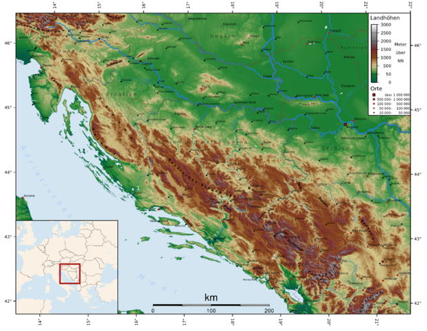
Deutsch: Topographie des Dinarischen Gebirges
English: Topography of the Dinaric Alps
Български: Динарски планини
Čeština: Dinárské hory
Español: Alpes Dináricos
Français : Alpes dinariques
Frysk: Dinaryske Alpen
Galego: Alpes Dináricos
עברית: האלפים הדינרים
Hrvatski: Dinaridi
Magyar: Dinári-hegység
Italiano: Alpi Dinariche
Lietuvių: Dinarų kalnynas
Nederlands: Dinarische Alpen
Norsk nynorsk: Dei dinariske Alpane
Norsk bokmål: De dinariske alper
Polski: Góry Dynarskie
Português: Alpes Dináricos
Română: Alpii Dinarici
Русский: Динарские Альпы
Slovenščina: Dinarsko gorstvo
Shqip: Alpet Dinarite
Türkçe: Dinar Alpleri
Українська: Дінарські Альпи |
| Date | |
| Source |
self-made with GMT using mainly SRTM30-Data. Missing data was completed using the GLOBE dataset. Edited with Inkscape. |
| Author | FelixReimann |
The map has been created with the Generic Mapping Tools: https://www.generic-mapping-tools.org/ using one or more of these public-domain datasets for the relief:
|

|
Permission is granted to copy, distribute and/or modify this document under the terms of the GNU Free Documentation License, Version 1.2 or any later version published by the Free Software Foundation; with no Invariant Sections, no Front-Cover Texts, and no Back-Cover Texts. A copy of the license is included in the section entitled GNU Free Documentation License. |
| This file is licensed under the Creative Commons Attribution-Share Alike 3.0 Unported license. | ||
| ||
| This licensing tag was added to this file as part of the GFDL licensing update. |
You want mountains or citys added to the map? Just tell me coordinates and names! FelixReimann 19:07, 19 April 2007 (UTC)
- If you need this map in another language, just give me the translations and I will make the rest. FelixReimann 11:37, 5 July 2007 (UTC)
File history
Click on a date/time to view the file as it appeared at that time.
| Date/Time | Thumbnail | Dimensions | User | Comment | |
|---|---|---|---|---|---|
| current | 16:16, 23 September 2011 | | 2,900 × 2,250 (7.61 MB) | HylgeriaK (talk | contribs) | color/saturation |
| 12:59, 18 November 2007 |  | 2,900 × 2,250 (7.74 MB) | FelixReimann (talk | contribs) | countries and borders added, some serbian cities added | |
| 23:23, 16 November 2007 |  | 2,900 × 2,250 (7.66 MB) | FelixReimann (talk | contribs) | serbian cities and some mountains added | |
| 11:49, 8 August 2007 |  | 2,900 × 2,250 (7.62 MB) | FelixReimann (talk | contribs) | cities added. source: http://www.world-gazetteer.com/ | |
| 14:35, 13 May 2007 |  | 3,306 × 2,339 (7.65 MB) | FelixReimann (talk | contribs) | cities added | |
| 09:58, 20 April 2007 |  | 2,839 × 2,209 (7.43 MB) | FelixReimann (talk | contribs) | Höhenskala und Koordinaten hinzugefügt | |
| 19:01, 19 April 2007 |  | 2,680 × 2,046 (7.38 MB) | FelixReimann (talk | contribs) | {{Information |Description=''de:'' Topographie des Dinarischen Gebirges<br/>''en:'' Topography of the Dinaric Alps |Source=self-made with GMT and Inkscape |Date=19.04.2007 |Author= ~~~ |other_versions= }} Category:Maps of mountains {{GFDL-GMT}} |
You cannot overwrite this file.
File usage on Commons
The following 3 pages use this file:
File usage on other wikis
The following other wikis use this file:
- Usage on af.wikipedia.org
- Usage on ar.wikipedia.org
- Usage on bg.wikipedia.org
- Usage on cs.wikipedia.org
- Usage on cy.wikipedia.org
- Usage on de.wikipedia.org
- Usage on diq.wikipedia.org
- Usage on el.wikipedia.org
- Usage on en.wikipedia.org
- Usage on eo.wikipedia.org
- Usage on es.wikipedia.org
- Usage on et.wikipedia.org
- Usage on fa.wikipedia.org
- Usage on fi.wikipedia.org
- Usage on fr.wikipedia.org
- Usage on fy.wikipedia.org
- Usage on he.wikipedia.org
- Usage on hr.wikipedia.org
- Usage on hu.wikipedia.org
- Usage on id.wikipedia.org
- Usage on ja.wikipedia.org
- Usage on ko.wikipedia.org
- Usage on ky.wikipedia.org
- Usage on lt.wikipedia.org
- Usage on nl.wikipedia.org
- Usage on nn.wikipedia.org
- Usage on no.wikipedia.org
- Usage on pl.wikipedia.org
- Usage on pl.wikivoyage.org
- Usage on pl.wiktionary.org
- Usage on pnb.wikipedia.org
- Usage on ru.wikipedia.org
- Usage on sh.wikipedia.org
- Usage on sk.wikipedia.org
- Usage on sq.wikipedia.org
- Usage on sr.wikipedia.org
- Usage on sv.wikipedia.org
- Usage on tr.wikipedia.org
- Usage on uk.wikipedia.org
- Usage on vi.wikipedia.org
- Usage on vls.wikipedia.org
View more global usage of this file.