File:Crête et creux barométriques d'altitude.jpg
Jump to navigation
Jump to search
No higher resolution available.
Crête_et_creux_barométriques_d'altitude.jpg (800 × 600 pixels, file size: 57 KB, MIME type: image/jpeg)
Captions
Captions
Add a one-line explanation of what this file represents
Summary[edit]
| Description |
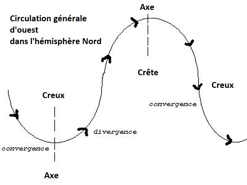
Français : Représentation idéale d'une suite de creux et crête barométrique en altitude dans l'hémisphère Nord. On peut y voir les axes de ces systèmes et les zones de convergence et divergence. DNas l'hémisphère Sud, la position des crêtes et creux est inversée mais les zones de zones de convergence et divergences restent les mêmes |
| Date | (UTC) |
| Source |
This file was derived from: Trough.jpg: |
| Author |
|
| This is a retouched picture, which means that it has been digitally altered from its original version. The original can be viewed here: Trough.jpg:
|
Licensing[edit]
I, the copyright holder of this work, hereby publish it under the following license:
| I, the copyright holder of this work, release this work into the public domain. This applies worldwide. In some countries this may not be legally possible; if so: I grant anyone the right to use this work for any purpose, without any conditions, unless such conditions are required by law. |
Original upload log[edit]
This image is a derivative work of the following images:
- File:Trough.jpg licensed with PD-self
- 2007-09-13T21:11:32Z A7x 400x300 (12196 Bytes) An idealized representation of alternating troughs and ridges in a westerly current, Northern Hemisphere. The areas of upper-level convergence (high pressure) and divergence (low pressure) are labeled. In the Southern Hemis
Uploaded with derivativeFX
File history
Click on a date/time to view the file as it appeared at that time.
| Date/Time | Thumbnail | Dimensions | User | Comment | |
|---|---|---|---|---|---|
| current | 18:28, 26 August 2013 | | 800 × 600 (57 KB) | Pierre cb (talk | contribs) | Ajouts |
| 14:48, 26 August 2013 |  | 800 × 600 (56 KB) | Pierre cb (talk | contribs) | == {{int:filedesc}} == {{Information |Description ={{fr|1=Représentation idéale d'une suite de creux et crête barométrique en altitude dans l'hémisphère Nord. On peut y voir les axes de ces systèmes et les zones de convergence et divergence. ... |
You cannot overwrite this file.
File usage on Commons
There are no pages that use this file.
File usage on other wikis
The following other wikis use this file:
- Usage on fr.wikipedia.org