File:CountriesRecognizingKosovo.svg
Jump to navigation
Jump to search

Size of this PNG preview of this SVG file: 800 × 349 pixels. Other resolutions: 320 × 139 pixels | 640 × 279 pixels | 1,024 × 446 pixels | 1,280 × 558 pixels | 2,560 × 1,115 pixels | 2,754 × 1,200 pixels.
Original file (SVG file, nominally 2,754 × 1,200 pixels, file size: 1.11 MB)
Captions
Captions
Add a one-line explanation of what this file represents

Summary[edit]
| Description |
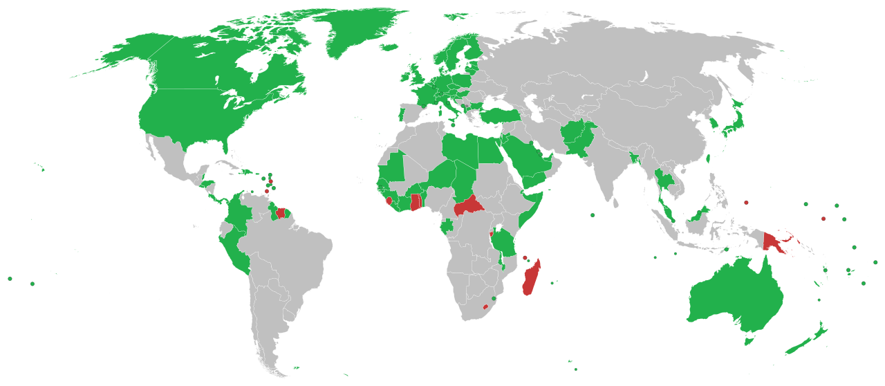
English: This is a map of countries recognizing independence of Kosovo
Recognise Kosovo as independent #808080 #C83737ff Withdrawn Hrvatski: Ovo je karta koja prikazuje države koje su priznale neovisnost Kosova
Priznaju neovisnost Kosova #808080 Español: Mapa de los países que reconocen la independencia de Kosovo
Deutsch: Länder in Grün erkennen den Kosovo als unabhängigen Staat an. Länder in rot haben die Anerkennung zurückgezogen.
Italiano: Mappa dei paesi che hanno riconosciuto l'indipendenza del Kosovo.
Português: Mapa dos países que reconhecem a independência do Kosovo.
Română: Aceasta este o hartă care arată recunoașterea independenței Republicii Kosovo pe plan internațional
Svenska: En karta över länder som formellt erkänner Kosovos självständighetsförklaring
Formellt erkänner Kosovos självständighetsförklaring #808080 #C83737ff Återkallat Türkçe: Kosova'nın bağımsızlığını tanıyan ülkelerin haritası
Українська: Карта країн, що визнають незалежність Косова.
العربية: هذه خريطة الدول التي تعترف بكوسوفو كدولة مستقلة الدول التي تعترف بكوسوفو كدولة مستقلة #808080 #C83737ff #CCCCCC الدول |
| Date |
17 September 2008 (original upload date) |
| Source |
English Wikipedia http://en.wikipedia.org/wiki/Image:CountriesRecognizingKosovo.png (Original text: March-May 2008 and ongoing) |
| Author | Alethiareg, ArturM, Balfabio, Avala, Mareklug, Cradel, Gugganij, Husond, en, Zscout370, en, Chech Explorer, Camptown, Hoshie, Nightstallion, Ijanderson977 / The original uploader was Alethiareg at English Wikipedia. |
| Other versions | CountriesRecognizingKosovo.png |
| SVG development |
Licensing[edit]
| This work has been released into the public domain by its author, Alethiareg at English Wikipedia. This applies worldwide. In some countries this may not be legally possible; if so: Alethiareg grants anyone the right to use this work for any purpose, without any conditions, unless such conditions are required by law. |
Original upload log[edit]
Transferred from en.wikipedia to Commons by EmilJ using CommonsHelper.
The original description page was here. All following user names refer to en.wikipedia.
- 14:22, 17 September 2008 940×415 (1.45 MB) EmilJ add Taiwan, omit circles for dependent territories
- 11:46, 16 September 2008 940×415 (1.45 MB) EmilJ Samoa recognized
- 14:20, 15 September 2008 940×415 (1.45 MB) EmilJ use CSS, add missing countries and territories
- 09:39, 15 September 2008 940×415 (1.49 MB) Alethiareg == Summary == {{Information |Description=This is a map of countries recognizing independence of Kosovo. |Author =User:Alethiareg, User:ArturM, User:Balfabio, [[User:Av
File history
Click on a date/time to view the file as it appeared at that time.
| Date/Time | Thumbnail | Dimensions | User | Comment | |
|---|---|---|---|---|---|
| current | 23:54, 1 January 2022 | | 2,754 × 1,200 (1.11 MB) | Kwamikagami (talk | contribs) | color integral constituents (Puerto Rico, New Caledonia, etc.) |
| 21:23, 26 April 2021 |  | 2,754 × 1,200 (1.05 MB) | NordNordWest (talk | contribs) | Reverted to version as of 06:02, 25 February 2021 (UTC) | |
| 16:58, 25 April 2021 |  | 512 × 223 (805 KB) | ויקי4800 (talk | contribs) | תיקון גבולות מדינת ישראל | |
| 06:02, 25 February 2021 |  | 2,754 × 1,200 (1.05 MB) | Liggliluff (talk | contribs) | Replacing file with BlankMap-World.svg for a better look, countries coloured by the style-code, should be correct to the last map, the image is cropped and ocean hidden, micro-nations have circles, and hovering shows popups | |
| 23:55, 8 February 2021 |  | 1,650 × 750 (918 KB) | Arianasmithy74 (talk | contribs) | Reverted to version as of 21:31, 29 December 2020 (UTC) | |
| 17:32, 7 February 2021 |  | 1,650 × 750 (918 KB) | Arianasmithy74 (talk | contribs) | Comoros now sent a letter to Kosovo saying that they still recognise Kosovo | |
| 21:31, 29 December 2020 |  | 1,650 × 750 (918 KB) | Arianasmithy74 (talk | contribs) | Brunei is green again. | |
| 21:18, 29 December 2020 |  | 1,650 × 750 (918 KB) | Arianasmithy74 (talk | contribs) | Nauru is now red as it withdrew recognition. | |
| 15:41, 27 December 2020 |  | 1,650 × 750 (918 KB) | Arianasmithy74 (talk | contribs) | Brunei is now green Also, 'nu' is Niue so it is not supposed to be red | |
| 11:05, 11 December 2020 |  | 1,650 × 750 (918 KB) | Kwamikagami (talk | contribs) | withdrawn recognition |
You cannot overwrite this file.
File usage on Commons
The following page uses this file:
File usage on other wikis
The following other wikis use this file:
- Usage on af.wikipedia.org
- Usage on ar.wikipedia.org
- Usage on arz.wikipedia.org
- Usage on ast.wikipedia.org
- Usage on bg.wikipedia.org
- Usage on bn.wikipedia.org
- Usage on ca.wikipedia.org
- Usage on cs.wikipedia.org
- Usage on de.wikipedia.org
- Benutzer:Generator
- Geschichte des Kosovo
- Liste der Gebiete mit begrenzter Anerkennung als Staat
- Kosovo
- Portal:Kosovo/Artikel des Monats
- Diskussion:Kosovo/Archiv/005
- Internationale Anerkennung des Kosovo
- Diskussion:Kosovo/Archiv/006
- Diskussion:Internationale Anerkennung des Kosovo/Archiv
- Wikipedia:Kartenwerkstatt/Archiv/2018-03
- Usage on el.wikipedia.org
- Usage on en.wikipedia.org
- Usage on es.wikipedia.org
- Usage on fa.wikipedia.org
- Usage on fi.wikipedia.org
- Usage on fr.wikipedia.org
- Usage on gl.wikipedia.org
- Usage on hr.wikipedia.org
- Usage on hu.wikipedia.org
- Usage on hy.wikipedia.org
- Usage on id.wikipedia.org
- Usage on incubator.wikimedia.org
- Usage on it.wikipedia.org
View more global usage of this file.