File:CanalZone.png
Jump to navigation
Jump to search

Size of this preview: 440 × 599 pixels. Other resolutions: 176 × 240 pixels | 520 × 708 pixels.
Original file (520 × 708 pixels, file size: 265 KB, MIME type: image/png)
Captions
Captions
Add a one-line explanation of what this file represents
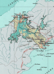
Map of the Panama Canal Zone. from the National Atlas archive copy at the Wayback Machine via American Memory.
This map was obtained from an edition of the National Atlas of the United States. Like almost all works of the U.S. federal government, works from the National Atlas are in the public domain in the United States.
Online access: NationalAtlas.gov | 1970 print edition: Library of Congress, Perry-Castañeda Library
|
Original upload log[edit]
| Date/Time | Dimensions | User | Comment |
|---|---|---|---|
| 29 April 2005, 04:29:04 | 520 × 708 (314279 bytes) | Hoshie (talk · contribs) | Map of the Panama Canal Zone. from the [http://www.nationalatlas.gov/ National Atlas] via [http://memory.loc.gov/ammem/gmdhtml/census3.html American Memory]. {{PD-USGov-Atlas}} |
File history
Click on a date/time to view the file as it appeared at that time.
| Date/Time | Thumbnail | Dimensions | User | Comment | |
|---|---|---|---|---|---|
| current | 09:24, 1 October 2014 | | 520 × 708 (265 KB) | RokerHRO (talk | contribs) | optipng -o7 → 23.74% decrease |
| 10:52, 29 August 2014 |  | 520 × 708 (348 KB) | GifTagger (talk | contribs) | Bot: Converting file to superior PNG file. (Source: CanalZone.gif). This GIF was problematic due to non-greyscale color table. |
You cannot overwrite this file.
File usage on Commons
The following 6 pages use this file:
File usage on other wikis
The following other wikis use this file:
- Usage on ang.wikipedia.org
- Usage on ar.wikipedia.org
- Usage on be.wikipedia.org
- Usage on bg.wikipedia.org
- Usage on bn.wikipedia.org
- Usage on ca.wikipedia.org
- Usage on cs.wikipedia.org
- Usage on da.wikipedia.org
- Usage on de.wikipedia.org
- Usage on en.wikipedia.org
- Usage on eo.wikipedia.org
- Usage on es.wikipedia.org
- Usage on fa.wikipedia.org
- Usage on fr.wikipedia.org
- Usage on he.wikipedia.org
- Usage on hu.wikipedia.org
- Usage on id.wikipedia.org
- Usage on it.wikipedia.org
- Usage on ja.wikipedia.org
- Usage on ka.wikipedia.org
- Usage on ko.wikipedia.org
- Usage on lt.wikipedia.org
View more global usage of this file.