File:British Isles Venn Diagram-mr.png
Jump to navigation
Jump to search
No higher resolution available.
British_Isles_Venn_Diagram-mr.png (453 × 457 pixels, file size: 29 KB, MIME type: image/png)
Captions
Captions
Add a one-line explanation of what this file represents
Summary[edit]
| Description |
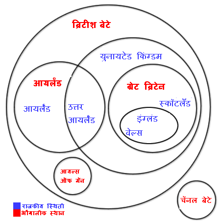
मराठी: युनायटेड किंग्डम/ ग्रेट ब्रिटेन चे राजकीय व भौगालीक अस्तित्व दाखवणारे चित्र
English: Update of British_Isles_Venn_Diagram.jpg Added Isle of Man. Original by User:Jfg284 Geographical locations are shown in red, political entities are in blue. |
| Date | 6 March 2006 (original upload date) |
| Source | Own work by the original uploader |
| Author | Seabhcan at English Wikipedia |
Licensing[edit]
| This work has been released into the public domain by its author, Seabhcan at English Wikipedia. This applies worldwide. In some countries this may not be legally possible; if so: Seabhcan grants anyone the right to use this work for any purpose, without any conditions, unless such conditions are required by law. |
File history
Click on a date/time to view the file as it appeared at that time.
| Date/Time | Thumbnail | Dimensions | User | Comment | |
|---|---|---|---|---|---|
| current | 08:05, 1 December 2006 | | 453 × 457 (29 KB) | महाराष्ट्र एक्सप्रेस (talk | contribs) | |
| 08:03, 1 December 2006 |  | 453 × 457 (29 KB) | महाराष्ट्र एक्सप्रेस (talk | contribs) | ||
| 14:29, 30 November 2006 |  | 453 × 457 (29 KB) | महाराष्ट्र एक्सप्रेस (talk | contribs) | मराठीत रुपांतरण | |
| 14:07, 30 November 2006 |  | 453 × 457 (28 KB) | महाराष्ट्र एक्सप्रेस (talk | contribs) | युनायटेड किंग्डम/ ग्रेट ब्रिटेन चे राजकीय व भौगालीक अस्तित्व दाखवणारे चित्र |
You cannot overwrite this file.
File usage on Commons
There are no pages that use this file.
File usage on other wikis
The following other wikis use this file:
- Usage on mr.wikipedia.org