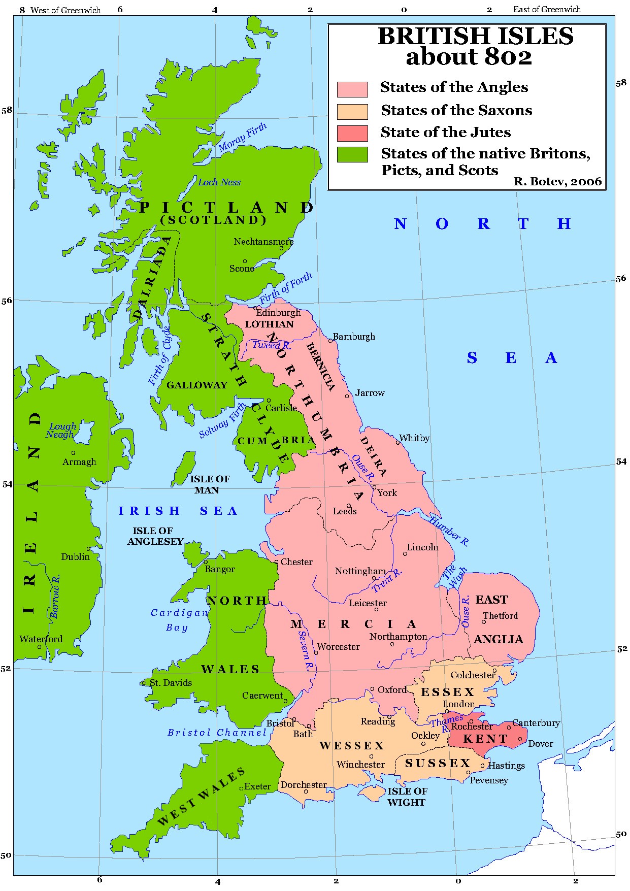
File:Britain 802.jpg
Jump to navigation
Jump to search
Size of this preview: 424 × 600 pixels. Other resolutions: 170 × 240 pixels | 339 × 480 pixels | 543 × 768 pixels | 1,241 × 1,755 pixels.
Original file (1,241 × 1,755 pixels, file size: 456 KB, MIME type: image/jpeg)
Captions
Captions
Add a one-line explanation of what this file represents

|
This map image could be re-created using vector graphics as an SVG file. This has several advantages; see Commons:Media for cleanup for more information. If an SVG form of this image is available, please upload it and afterwards replace this template with
{{vector version available|new image name}}.
It is recommended to name the SVG file “Britain 802.svg”—then the template Vector version available (or Vva) does not need the new image name parameter. |


Изработено от Потребител:Lotroo ...
| This work has been released into the public domain by its author, Lotroo. This applies worldwide. In some countries this may not be legally possible; if so: |
File history
Click on a date/time to view the file as it appeared at that time.
| Date/Time | Thumbnail | Dimensions | User | Comment | |
|---|---|---|---|---|---|
| current | 21:17, 4 June 2022 | | 1,241 × 1,755 (456 KB) | Bodrugan (talk | contribs) | Reverted to version as of 02:09, 31 May 2022 (UTC) reverting to more accurate version without spelling mistakes and unwanted lines |
| 19:18, 31 May 2022 |  | 1,241 × 1,755 (670 KB) | GPinkerton (talk | contribs) | Reverted to version as of 09:49, 25 August 2006 (UTC) COM:CROP | |
| 02:09, 31 May 2022 |  | 1,241 × 1,755 (456 KB) | Bodrugan (talk | contribs) | Correcting western border of Wessex for 802 | |
| 00:07, 4 December 2020 |  | 1,241 × 1,755 (1.11 MB) | Zacwill (talk | contribs) | *Further* errors corrected | |
| 23:05, 3 December 2020 |  | 1,241 × 1,755 (1.11 MB) | Zacwill (talk | contribs) | Further errors corrected | |
| 22:55, 3 December 2020 |  | 1,241 × 1,755 (1.11 MB) | Zacwill (talk | contribs) | Corrected spelling mistakes and removed random lines | |
| 16:20, 20 May 2020 |  | 1,241 × 1,755 (1.15 MB) | Claude Zygiel (talk | contribs) | West Wales (relative autonomy) | |
| 09:49, 25 August 2006 |  | 1,241 × 1,755 (670 KB) | Lotroo~commonswiki (talk | contribs) | Category:Maps of the history of BritainИзработено от Потребител:Lotroo ... {{PD-user|Lotroo}} |
You cannot overwrite this file.
File usage on Commons
The following 3 pages use this file:
File usage on other wikis
The following other wikis use this file:
- Usage on arz.wikipedia.org
- Usage on azb.wikipedia.org
- Usage on el.wikipedia.org
- Usage on en.wikipedia.org
- Usage on fa.wikipedia.org
- Usage on fr.wikipedia.org
- Usage on ga.wikipedia.org
- Usage on it.wikipedia.org
- Usage on lt.wikipedia.org
- Usage on lv.wikipedia.org
- Usage on pl.wikipedia.org
- Usage on pt.wikipedia.org
- Usage on ro.wikipedia.org
- Usage on ru.wikipedia.org
- Usage on sl.wikipedia.org
- Usage on th.wikipedia.org
- Usage on vi.wikipedia.org