File:Bezirke Österreichs Statutarstädte Kennzeichen.svg
Jump to navigation
Jump to search

Size of this PNG preview of this SVG file: 640 × 361 pixels. Other resolutions: 320 × 181 pixels | 1,024 × 578 pixels | 1,280 × 722 pixels | 2,560 × 1,444 pixels.
Original file (SVG file, nominally 640 × 361 pixels, file size: 136 KB)
Captions
Captions
Add a one-line explanation of what this file represents
Summary[edit]
| Description |
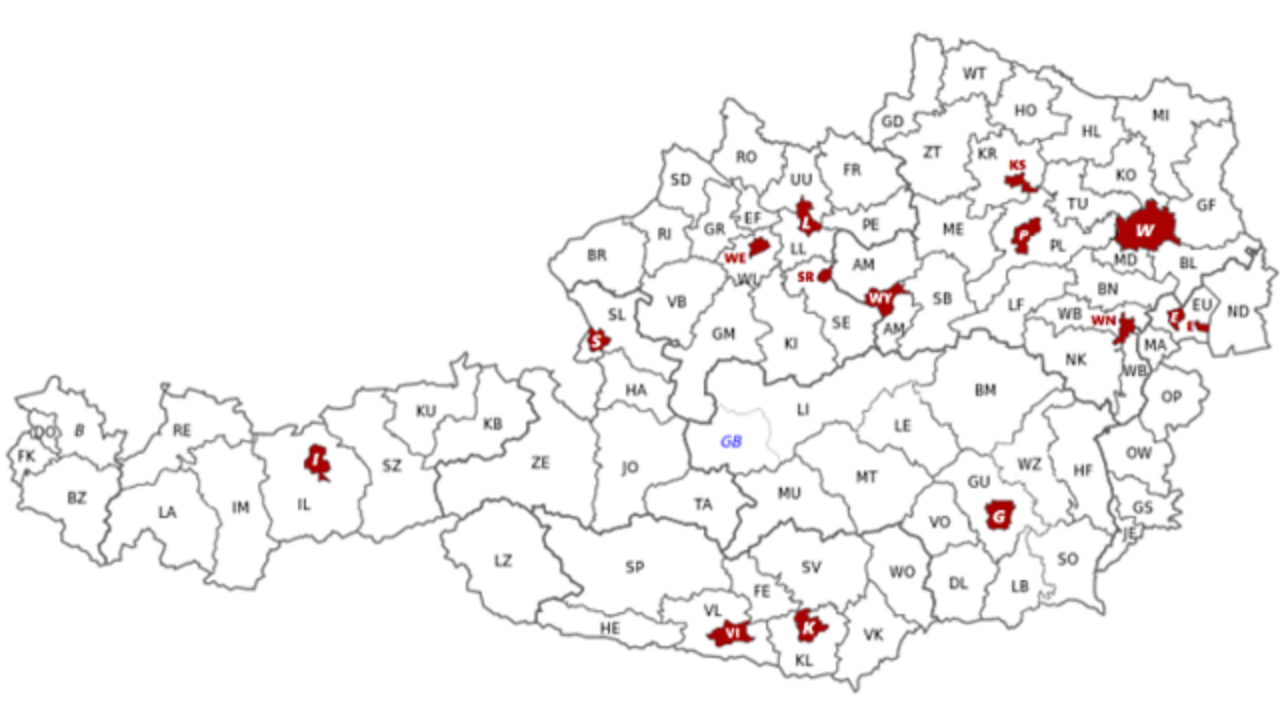
Deutsch: Karte der Österreichischen Bezirke inklusive KFZ-Kennzeichen. Bezirke mit rotem Hintergrund und fetter Schrift sind Statutarstädte. Landeshauptstädte sind kursiv gesetzt, die Expositur Gröbming in blauer Schrift. Basierend auf File:Gemeinden_Österreichs.svg und File:Bezirke_Austria-A.gif. English: Map of austrian districts, including car licence plates. Districts in red and width bold font are "Statutarstädte" (statutory cities). Provincial capitals are oblique, "Expositur Gröbming" is in blue font. Based on File:Gemeinden_Österreichs.svg and File:Bezirke_Austria-A.gif. |
| Date | |
| Source | Own work |
| Author | Sgt bilko rework=Kontrollstellekundl |
| SVG development | This map was created with an unknown SVG tool by Kontrollstelle Kundl. |

Licensing[edit]
I, the copyright holder of this work, hereby publish it under the following license:
This file is licensed under the Creative Commons Attribution-Share Alike 3.0 Unported license.
- You are free:
- to share – to copy, distribute and transmit the work
- to remix – to adapt the work
- Under the following conditions:
- attribution – You must give appropriate credit, provide a link to the license, and indicate if changes were made. You may do so in any reasonable manner, but not in any way that suggests the licensor endorses you or your use.
- share alike – If you remix, transform, or build upon the material, you must distribute your contributions under the same or compatible license as the original.
| Annotations | This image is annotated: View the annotations at Commons |
File history
Click on a date/time to view the file as it appeared at that time.
| Date/Time | Thumbnail | Dimensions | User | Comment | |
|---|---|---|---|---|---|
| current | 12:58, 1 January 2017 | | 640 × 361 (136 KB) | Kontrollstellekundl (talk | contribs) | Stand 2017 |
| 09:11, 18 April 2015 |  | 678 × 382 (137 KB) | Kontrollstellekundl (talk | contribs) | Statutarstädte neu beschriftet | |
| 09:47, 10 January 2015 |  | 800 × 449 (133 KB) | Kontrollstellekundl (talk | contribs) | Steiermark: neue Bezirksgrenzen 2015 | |
| 11:41, 2 January 2013 |  | 711 × 399 (873 KB) | Sgt bilko (talk | contribs) | neue steirische Bezirke (BM, HF, SO) | |
| 12:51, 1 January 2012 |  | 711 × 399 (890 KB) | Sgt bilko (talk | contribs) | Expositur Bad Aussee entfernt | |
| 12:39, 1 January 2012 |  | 711 × 399 (892 KB) | Sgt bilko (talk | contribs) | neuer Bezirk Murtal | |
| 13:23, 1 October 2011 |  | 711 × 399 (898 KB) | Sgt bilko (talk | contribs) |
You cannot overwrite this file.
File usage on Commons
The following 8 pages use this file:
- User:Chumwa/OgreBot/Potential transport maps/2017 January 1-10
- User:Chumwa/OgreBot/Transport Maps/2015 April 11-20
- User:Chumwa/OgreBot/Transport Maps/2017 January 1-10
- User:Chumwa/OgreBot/Travel and communication maps/2017 January 1-10
- User:Sgt bilko/Gallery
- File:Bezirke Austria-A.gif
- File:Bezirke Österreichs.svg
- File:Bezirke Österreichs Statutarstädte.svg
File usage on other wikis
The following other wikis use this file:
- Usage on de.wikipedia.org