File:Arab League-Map-WS.PNG
Jump to navigation
Jump to search

Size of this preview: 800 × 352 pixels. Other resolutions: 320 × 141 pixels | 640 × 282 pixels | 1,427 × 628 pixels.
Original file (1,427 × 628 pixels, file size: 36 KB, MIME type: image/png)
Captions
Captions
Add a one-line explanation of what this file represents
Summary[edit]
| Description |
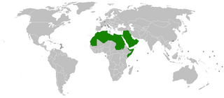
English: Arab League World Map |
| Date | 6 September 2006 (original upload date) |
| Source | Transferred from en.wikipedia to Commons. |
| Author | Arab Hafez at English Wikipedia |
Licensing[edit]
Arab Hafez at the English-language Wikipedia, the copyright holder of this work, hereby publishes it under the following license:
| This file is licensed under the Creative Commons Attribution-Share Alike 3.0 Unported license. Subject to disclaimers. | ||
| Attribution: Arab Hafez at the English-language Wikipedia | ||
| ||
| This licensing tag was added to this file as part of the GFDL licensing update. |

|
Permission is granted to copy, distribute and/or modify this document under the terms of the GNU Free Documentation License, Version 1.2 or any later version published by the Free Software Foundation; with no Invariant Sections, no Front-Cover Texts, and no Back-Cover Texts. A copy of the license is included in the section entitled GNU Free Documentation License. Subject to disclaimers. |
Original upload log[edit]
The original description page was here. All following user names refer to en.wikipedia.
- 2006-09-06 17:55 Arab Hafez 1427×628× (47920 bytes) Arab League World Map
File history
Click on a date/time to view the file as it appeared at that time.
| Date/Time | Thumbnail | Dimensions | User | Comment | |
|---|---|---|---|---|---|
| current | 15:22, 26 January 2018 | | 1,427 × 628 (36 KB) | Maphobbyist (talk | contribs) | Added borders of Montenegro which was forgotten. |
| 20:30, 22 January 2018 |  | 1,427 × 628 (37 KB) | Maphobbyist (talk | contribs) | South Sudan has become independent on July 9, 2011. Sudan and South Sudan are shown with the new international border between them. | |
| 07:33, 23 May 2014 |  | 1,427 × 628 (47 KB) | FastilyClone (talk | contribs) | from w:File:Arab League-Map-WS.PNG (CM) |
You cannot overwrite this file.
File usage on Commons
The following 7 pages use this file:
File usage on other wikis
The following other wikis use this file:
- Usage on ar.wikipedia.org
- Usage on ca.wikipedia.org
- Usage on en.wikipedia.org
- Usage on he.wikipedia.org
- Usage on new.wikipedia.org
- Usage on ru.wikipedia.org