File:Antarctic bottom water.svg

Original file (SVG file, nominally 745 × 470 pixels, file size: 42 KB)
Captions
Captions
Summary[edit]
| Description |
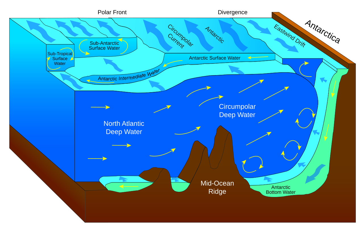
English: Water mass bodies of the Southern Ocean.
Català: Cossos de massa d'aigua de l'oceà austral. |
| Date | |
| Source |
 |
| Author | Fred the Oyster |
| Other versions |
File:Antarctic bottom water.svg has 2 translations.
|


|
This SVG file contains embedded text that can be translated into your language, using any capable SVG editor, text editor or the SVG Translate tool. For more information see: About translating SVG files. |
This file is translated using SVG <switch> elements. All translations are stored in the same file! Learn more.
For most Wikipedia projects, you can embed the file normally (without a To translate the text into your language, you can use the SVG Translate tool. Alternatively, you can download the file to your computer, add your translations using whatever software you're familiar with, and re-upload it with the same name. You will find help in Graphics Lab if you're not sure how to do this. |
Licensing[edit]
- You are free:
- to share – to copy, distribute and transmit the work
- to remix – to adapt the work
- Under the following conditions:
- attribution – You must give appropriate credit, provide a link to the license, and indicate if changes were made. You may do so in any reasonable manner, but not in any way that suggests the licensor endorses you or your use.
- share alike – If you remix, transform, or build upon the material, you must distribute your contributions under the same or compatible license as the original.
File history
Click on a date/time to view the file as it appeared at that time.
| Date/Time | Thumbnail | Dimensions | User | Comment | |
|---|---|---|---|---|---|
| current | 00:50, 17 March 2022 | | 745 × 470 (42 KB) | Manlleus (talk | contribs) | File uploaded using svgtranslate tool (https://svgtranslate.toolforge.org/). Added translation for ca. |
| 11:46, 7 September 2014 |  | 745 × 470 (36 KB) | Fred the Oyster (talk | contribs) | User created page with UploadWizard |
You cannot overwrite this file.
File usage on Commons
The following 4 pages use this file:
File usage on other wikis
The following other wikis use this file:
- Usage on ar.wikipedia.org
- تسونامي
- قاعدة الموجة
- بحر هامشي
- شعب حلقي
- قاع البحر
- مستوى سطح البحر
- الصفائح التكتونية
- دورة حرارية ملحية
- مد وجزر
- حدود متقاربة
- طاقة مدجزرية
- محيط (جغرافيا)
- تأثير كوريوليس
- طاقة موجية
- ارتفاع منسوب البحار
- تلوث البحار
- حالة البحر
- حيد وسط محيط
- خندق محيطي
- رف قاري
- منطقة مضاءة
- منطقة عميقة
- منطقة متوسطة العمق
- منطقة البحر المفتوح
- موجة رياح
- تيار محيطي
- علم المحيطات
- موجة جاذبية
- قوة المد والجزر
- ماء البحر
- منحدر حراري
- أمواج روسبي
- تيار الخليج
- تيار همبولت
- وصف المياه
- موجة ارتطام
- سوليتون
- منفس مائي حراري
- طبوغرافية سطح المحيط
- تيار دوراني أرضي
- منحنى سطح البحر
- جيوت
- توزيع حرمائي
- عمق البحر
- حدود متباعدة
- تمدد قاع البحر
- جبل بحري
- توقف الدوران الحراري الملحي
- انضواء
- دوامة مائية
View more global usage of this file.