File:Aerial View of Clifton Heights, PA facing southeast.jpg
Jump to navigation
Jump to search

Size of this preview: 747 × 600 pixels. Other resolutions: 299 × 240 pixels | 598 × 480 pixels | 956 × 768 pixels | 1,275 × 1,024 pixels | 2,550 × 2,048 pixels | 2,855 × 2,293 pixels.
Original file (2,855 × 2,293 pixels, file size: 895 KB, MIME type: image/jpeg)
Captions
Captions
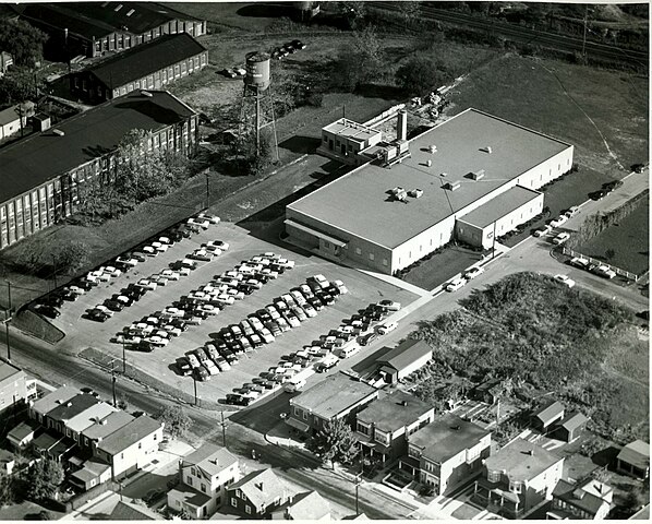
Aerial photograph from the early 1950s, detailing Clifton Precision and Kent Mills industrial buildings.
Summary[edit]
| Description |
English: Building in the foreground is the Clifton Precision factory. Buildings to the left are part of the Kent Mills textile factory. Railroad in background is the present-day SEPTA Media-Wawa line. |
| Date | Unknown date |
| Source | Own work |
| Author | Bnc319 |
| Camera location | | View this and other nearby images on: OpenStreetMap |
|---|
Licensing[edit]
I, the copyright holder of this work, hereby publish it under the following license:
This file is licensed under the Creative Commons Attribution 4.0 International license.
- You are free:
- to share – to copy, distribute and transmit the work
- to remix – to adapt the work
- Under the following conditions:
- attribution – You must give appropriate credit, provide a link to the license, and indicate if changes were made. You may do so in any reasonable manner, but not in any way that suggests the licensor endorses you or your use.
File history
Click on a date/time to view the file as it appeared at that time.
| Date/Time | Thumbnail | Dimensions | User | Comment | |
|---|---|---|---|---|---|
| current | 17:19, 22 April 2024 | | 2,855 × 2,293 (895 KB) | Bnc319 (talk | contribs) | Uploaded own work with UploadWizard |
You cannot overwrite this file.
File usage on Commons
There are no pages that use this file.