File:A General Chart of the West Indies- With Additions from the Latest Navigators WDL21.png
Jump to navigation
Jump to search

Size of this preview: 800 × 498 pixels. Other resolutions: 320 × 199 pixels | 640 × 398 pixels | 1,024 × 637 pixels | 1,280 × 797 pixels | 1,645 × 1,024 pixels.
Original file (1,645 × 1,024 pixels, file size: 3.12 MB, MIME type: image/png)
Captions
Captions
Add a one-line explanation of what this file represents
Summary[edit]
| Author |
Русский: Шпеер, Джозеф Смит
Français : Speer, Joseph Smith
English: Speer, Joseph Smith
中文:斯佩尔, 约瑟夫·史密斯
Português: Speer, Joseph Smith
العربية: سبير, جوزيف سميث
Español: Speer, Joseph Smith |
| Title |
Русский: Общая карта Вест-Индии: С дополнительными сведениями последних морских путешествий
Français : Une carte générale des Indes occidentales : avec des ajouts des tout derniers navigateurs
English: A General Chart of the West Indies: With Additions from the Latest Navigators
中文:西印度群岛总海图: 添加了最新航海家的资料
Português: Um mapa geral das Índias Ocidentais: Com atualizações dos mais recentes navegadores
العربية: رسم بياني عام لجزر الهند الغربية: مع إضافات من آخر الملاحين
Español: Una carta de navegación general de las Indias Occidentales: con aportes de los últimos navegantes |
| Description |
Русский: Капитан Джозеф Смит Спир был английским мореплавателем, прослужившим 21 год на побережье Москито (Мискито), территории нынешней Никарагуа. Впоследствии он составил подробные карты Вест-Индии, опираясь на собственное знание региона.
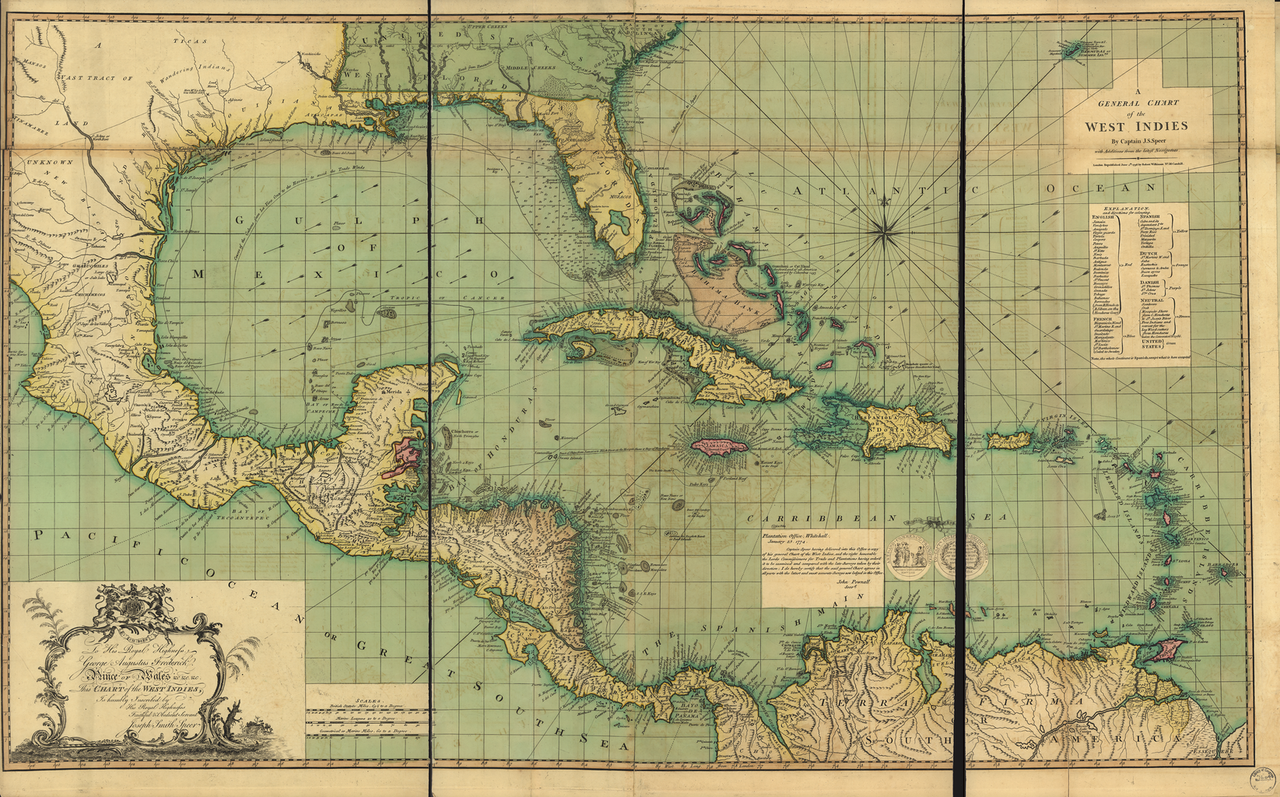
В 1776-м году он опубликовал "Путеводитель по Вест-Индии", состоявший из 13 карт; дополненное издание, содержавшее 26 карт, вышло в свет в 1771-м году. Представленная здесь "Общая карта Вест-Индии"представляет собой подробную карту крупного размера (71 на 117 см). Составлена по более ранней версии 1774-го года, "с дополнениями, внесенными современными мореплавателями". Английские, французские, голландские и датские территории приведены и обозначены различными цветами. В состав Соединенных Штатов, обозначенных зеленым цветом, еще не входит Флорида и территории к западу от Миссисипи. Карибский регион; Вест-Индия Français : Le Capitaine Joseph Smith Speer était un marin anglais qui servit pendant 21 ans sur la côte des Mosquitos dans ce qui est aujourd'hui le Nicaragua. Il créa ensuite des cartes détaillées des Antilles basées sur ses connaissances personnelles de cette région. En 1766, il publia The West-India Pilot (Le pilote des Antilles) qui contenait 13 cartes, suivi d'une édition amplifiée contenant 26 cartes en 1771. Cette carte générale des Indes occidentales est une grande carte détaillée (71 sur 117 centimètres). Elle est basée sur une carte antérieure datant de 1774 « avec des ajouts des tout derniers navigateurs ». Les territoires anglais, français, espagnols, néerlandais et danois y sont indiqués et représentés par des couleurs différentes. Les États-Unis, en vert, ne comprennent pas encore la Floride, ni aucun territoire à l'ouest du Mississippi.
Région des Caraïbes; Antilles English: Captain Joseph Smith Speer was an English mariner who served 21 years on the Mosquito (Miskito) Coast in what is now Nicaragua. He later created detailed maps of the West Indies based on his first-hand knowledge of the region. In 1766 he published The West-India Pilot containing 13 maps, followed by an enlarged edition with 26 maps in 1771. A General Chart of the West Indies, shown here, is a large, detailed map (71 by 117 centimeters). It is based on an earlier map from 1774, “with Additions from the latest Navigators.” English, French, Spanish, Dutch, and Danish territories are listed and coded with different colors. The United States, shown in green, does not yet include Florida or any territory west of the Mississippi.
Caribbean Area; West Indies 中文:约瑟夫·斯密斯·施瑟佩尔船长是一名英国籍的海员,在莫斯基托海岸(米斯基托)工作了21年。 后来他根据自己对该地区了解的第一手资料绘制了很多西印度群岛的详细地图。 1766 年,他出版了 《西印度群岛领航员》, 其中共包含 13 张地图,随后 1771 年的扩充版共包含 26 张地图。 这里展示的《西印度群岛总图》是一张非常详细的大型地图(71 厘米乘以 117 厘米)。 这幅地图主要基于1774年后早期的一幅地图,“将来自领航员的最新信息补充了进去”。 英国、法国、西班牙、荷兰和丹麦的领土各自用不同的颜色标识了出来。 美国则用绿色标识的,佛罗里达州和密西西比河以西的地方没有包含进去。
加勒比海地区; 西印度群岛 Português: O Capitão Joseph Smith Speer era um marinheiro inglês que serviu 21 anos na Costa dos Mosquitos (Misquito), onde hoje fica a Nicarágua. Mais tarde, ele criou mapas detalhados das Índias Ocidentais com base em seu conhecimento pioneiro sobre a região. Em 1766, ele publicou O Piloto das Índias Ocidentais contendo 13 mapas, seguido por uma edição ampliada, com 26 mapas, em 1771. Um mapa geral das Índias Ocidentais, mostrado aqui, é um mapa grande e detalhado (71 por 117 centímetros). Ele está baseado em um mapa anterior de 1774, "com atualizações dos mais recentes navegadores." Os territórios ingleses, franceses, espanhóis, holandeses e dinamarqueses estão listados e codificados em cores diferentes. Os Estados Unidos, mostrados em verde, não incluem ainda a Flórida nem qualquer território a oeste do Mississipi.
Região do Caribe; Índias Ocidentais العربية: كان الكابتن جوزيف سميث سبير ملاحا إنجليزيا خدم لمدة 21 سنة على ساحل الموسكيتو (ميسكيتو) في ما يُعرف بنيكاراغوا حاليا. وأنتج في وقت لاحق خرائط تفصيلية لجزر الهند الغربية مبنية على معرفته المباشرة عن المنطقة. في 1766 أصدر كتاب ربان الهند الغربية الذي كان يحتوي على 13 خريطة، وألحقه بطبعة موسعة تحتوي على 26 خريطة في 1771. إن الخريطة الشاملة لجزر الهند الغربية المبينة هنا هي خريطة تفصيلية كبيرة (71×117 سنتيمتر). وهي مرتكزة على خريطة سابقة لها من 1774، "مع إضافات من أحدث الملاحين". كما تدرج الأراضي الانجليزية والفرنسية والاسبانية والهولندية والدانماركية وتُرمز بألوان مختلفة. والولايات المتحدة، المبيّنة في اللون الأخضر، لا تشمل حتى الآن فلوريدا، أو أي إقليم إلى الغرب من الميسيسيبي.
منطقة البحر الكاريبي; جزر الهند الغربية Español: El Capitán Joseph Smith Speer fue un marinero inglés que sirvió durante 21 años en la Costa de Mosquitos (Mosquitia), hoy en día Nicaragua. Más tarde, dibujó mapas detallados de las Indias Occidentales basados en su conocimiento de primera mano de la región. En 1766 publicó El Piloto de las Indias Occidentales, que contenía 13 mapas, y al que siguió una edición ampliada con 26 mapas en 1771. Una carta de navegación general de las Indias Occidentales, que se muestra aquí, es un mapa amplio y detallado (71 por 117 centímetros). Está basado en un mapa anterior, de 1774, «con adiciones de los últimos Navegantes». Se muestran los territorios ingleses, franceses, españoles, holandeses y daneses, codificados con colores diferentes. Estados Unidos, en verde, aún no incluye Florida ni los territorios al oeste del Misisipi.
Zona del Caribe; Indias Occidentales |
| Date | 4 June 1796 |
| Medium |
Русский: Карты
Français : Cartes
English: Maps
中文:地图
Português: Mapas
العربية: خرائط
Español: Mapas |
| Dimensions |
English: 1 map : color ; 71 x 117 centimeters |
| Collection |
Русский: Библиотека Конгресса
Français : Bibliothèque du Congrès
English: Library of Congress
中文:国会图书馆
Português: Biblioteca do Congresso
العربية: مكتبة الكونغرس
Español: Biblioteca del Congreso |
| Place of creation |
Русский: Латинская Америка и Карибский бассейн
Français : Amérique latine et Caraïbes
English: Latin America and the Caribbean
中文:拉丁美洲和加勒比海地区
Português: América Latina e Caribe
العربية: أمريكا اللاتينية والكاريبي
Español: América Latina y el Caribe |
| References | http://hdl.loc.gov/loc.wdl/dlc.21 |
| Source/Photographer |
|
Licensing[edit]
|
This is a faithful photographic reproduction of a two-dimensional, public domain work of art. The work of art itself is in the public domain for the following reason:
The official position taken by the Wikimedia Foundation is that "faithful reproductions of two-dimensional public domain works of art are public domain".
This photographic reproduction is therefore also considered to be in the public domain in the United States. In other jurisdictions, re-use of this content may be restricted; see Reuse of PD-Art photographs for details. | ||||
File history
Click on a date/time to view the file as it appeared at that time.
| Date/Time | Thumbnail | Dimensions | User | Comment | |
|---|---|---|---|---|---|
| current | 04:39, 11 March 2014 | | 1,645 × 1,024 (3.12 MB) | Fæ (talk | contribs) | =={{int:filedesc}}== {{Artwork |artist = |author ={{ru|1=Шпеер, Джозеф Смит}} {{fr|1=Speer, Joseph Smith}} {{en|1=Speer, Joseph Smith}} {{zh|1=斯佩尔, 约瑟夫·史密斯}} {{pt|1=Speer, Joseph Smith}} {{ar|1=سبير, جوزيف س... |
You cannot overwrite this file.
File usage on Commons
The following 2 pages use this file: