File:360° Gottvaterspitze Walgau Rätikon.jpg
Jump to navigation
Jump to search

Size of this preview: 798 × 176 pixels. Other resolutions: 320 × 71 pixels | 640 × 141 pixels | 1,024 × 226 pixels | 1,280 × 282 pixels | 8,210 × 1,811 pixels.
Original file (8,210 × 1,811 pixels, file size: 11.68 MB, MIME type: image/jpeg)
Captions
Captions
Add a one-line explanation of what this file represents
| 360° | View in 360° panoramic viewer
|
|---|
| Description |
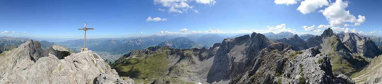
Deutsch: 360° Panorama auf der 2.438 m ü.A. gelegenen Gottvaterspitze. Sie sitzt nördlich der Zimba 2.643m im Sarotlatal und wird als Hausberg der Bludenzer bezeichnet. Zwischen der Zimba und der Gottvaterspitze liegt der Sattel "Eisernes Törle" gefolgt vom Großen Valkastiel 2.449m und dem Steintälikopf 2.443m. Der Aufstieg führt über das Sarotlatal vom Bürserberg oder Brand kommend in ca. 2,5 Stunden auf die Sarotlahütte. Von dort führen die Wege entweder zum Zwölferkopf, zu den Sarotlahörner, der Zimba, dem Gr. Valkastiel oder zur Gottvaterspitze. Für die Touren müssen ca. 4,5 Stunden für den Aufstieg und die Zeit für den Abstieg geplant werden. Gute Kondition und Trittsicherheit sind vorausgesetzt.
|
||
| Date | |||
| Source | Own work | ||
| Author |
|
||
| Permission (Reusing this file) |
I, the copyright holder of this work, hereby publish it under the following license: This file is licensed under the Creative Commons Attribution-Share Alike 3.0 Austria license.
 |

|
| Camera location | | View this and other nearby images on: OpenStreetMap |
|---|
| Annotations | This image is annotated: View the annotations at Commons |
File history
Click on a date/time to view the file as it appeared at that time.
| Date/Time | Thumbnail | Dimensions | User | Comment | |
|---|---|---|---|---|---|
| current | 09:21, 8 September 2013 | 8,210 × 1,811 (11.68 MB) | Böhringer (talk | contribs) | {{Pano360|horizon=65}} {{Information |Description= {{de|1=360° Panorama auf der 2.438 m ü.A. gelegenen Gottvaterspitze. Sie sitzt nördlich der Zimba 2.643m in der Vandanser Steinwand... |
You cannot overwrite this file.
File usage on Commons
The following 17 pages use this file:
- Exzellente Bilder aus Vorarlberg
- User:Böhringer
- User:Böhringer/Archive 5
- User:Miya/sandbox/FP/2013/Galleries/Table
- Commons:Featured picture candidates/File:360° Gottvaterspitze Walgau Rätikon.jpg
- Commons:Featured picture candidates/Log/September 2013
- Commons:Featured pictures/Places/Natural/Austria
- Commons:Featured pictures/Places/Panoramas
- Commons:Featured pictures/chronological/2013-B
- Commons:Picture of the Year/2013/Candidates
- Commons:Picture of the Year/2013/Galleries/Table
- Commons:Picture of the Year/2013/R1/Gallery/2013-B
- Commons:Picture of the Year/2013/R1/Gallery/ALL
- Commons:Picture of the Year/2013/R1/Gallery/M09
- Commons:Picture of the Year/2013/R1/Gallery/Panoramic views
- Commons:Picture of the Year/2013/R1/Results/Candidates
- Commons:Picture of the Year/2013/R1/v/360° Gottvaterspitze Walgau Rätikon.jpg
File usage on other wikis
The following other wikis use this file:
- Usage on de.wikipedia.org
- Usage on fr.wikipedia.org