This is a Valued image. Click here for more information.

File:31 - Buzet-sur-Tarn - Le Tarn - Les piles de l'ancien pont détruit en 1718 et l'emplacement du Bac.jpg

From Wikimedia Commons, the free media repository
Jump to navigation Jump to search

Original file(8,256 × 5,504 pixels, file size: 31.36 MB, MIME type: image/jpeg)

Captions

Captions

Add a one-line explanation of what this file represents

Summary

[edit]

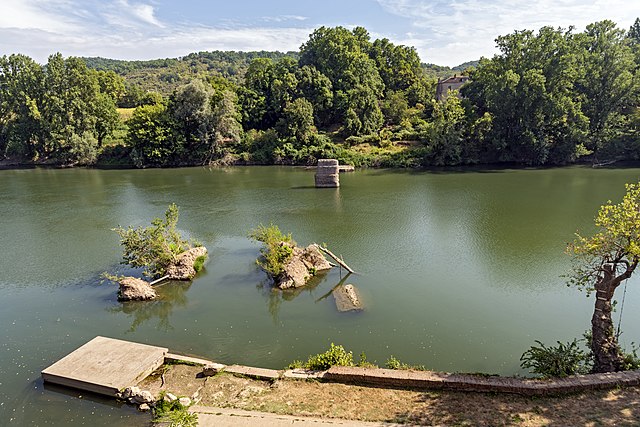
Buzet-sur-Tarn - Tarn river - Pillars of the old 13th century bridge destroyed in 1718, and the remains of the ferry

VI seal

This image has been assessed under the valued image criteria and is considered the most valued image on Commons within the scope: Buzet-sur-Tarn - Tarn river - Pillars of the old 13th-century bridge destroyed in 1718, and the remains of the ferry. You can see its nomination here.

Description
English: Buzet-sur-Tarn - The pillars of the old 13th century bridge destroyed in 1718, and the remains of the ferry that was active from 1738 to 1839.
Français : Buzet-sur-Tarn - Les piles de l'ancien pont du XIIIe siècle détruit en 1718, et les vestiges du bac actif de 1738 à 1839.
Date Taken on 10 August 2020, 11:05 (according to Exif data)
Source Own work
Author Didier Descouens
Permission
(Reusing this file)
This file is copyrighted and has been released under a license which is incompatible with Facebook's licensing terms. It is not permitted to upload this file at Facebook.
I, the copyright holder of this work, hereby publish it under the following license:
w:en:Creative Commons
attribution share alike
This file is licensed under the Creative Commons Attribution-Share Alike 4.0 International license.
You are free:
  • to share – to copy, distribute and transmit the work
  • to remix – to adapt the work
Under the following conditions:
  • attribution – You must give appropriate credit, provide a link to the license, and indicate if changes were made. You may do so in any reasonable manner, but not in any way that suggests the licensor endorses you or your use.
  • share alike – If you remix, transform, or build upon the material, you must distribute your contributions under the same or compatible license as the original.
Camera location43° 46′ 51.19″ N, 1° 38′ 05.34″ E Kartographer map based on OpenStreetMap.View this and other nearby images on: OpenStreetMapinfo

[[Category:Valued Images by Archaeodontosaurus]

File history

Click on a date/time to view the file as it appeared at that time.

Date/TimeThumbnailDimensionsUserComment
current04:53, 19 August 2020Thumbnail for version as of 04:53, 19 August 20208,256 × 5,504 (31.36 MB)Archaeodontosaurus (talk | contribs){{Information |Description= |Source={{own}} |Date= |Author= Archaeodontosaurus |Permission= |other_versions= }}

File usage on other wikis

The following other wikis use this file:

Metadata