File:19940703diaoyutai.jpg
19940703diaoyutai.jpg (707 × 446 pixels, file size: 12 KB, MIME type: image/jpeg)
Captions
Captions
Summary[edit]
| Description19940703diaoyutai.jpg |
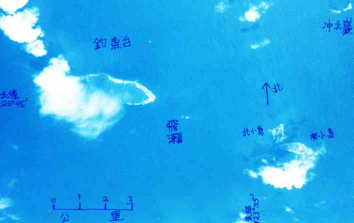
English: The Diaoyutai Islands are located 200 km ENE of Taipei, capitol of Taiwan. Diaoyutai means "fishing platform" in Chinese. I happened to take this a photo of Diaoyutai Is. 此釣魚台之空照為我攝。
We see light beaches and dark vegetation. 海灘白色,暗的是植物。 Elevations of highest points of islands 各島最高點:釣魚台 Diaoyutai 383 m, 北小島 Beixiaodao 135 m, Nanxiaodao 南小島 149 m, 沖北岩 Chongbeiyan 28 m。[Statistics from Taiwan Gov't 1:50000 topo maps. 為何北小島長得與經建版圖不一樣?] north is up; scale in km. Please turn this picture upside down for original from-plane viewing feeling; 若要原從飛機看感,相片請倒放 taken 3 July 1994. weiyun at mac.com said on Sep 11 2000:
|
| Date | UTC |
| Source | Own work |
| Author | Jidanni |
| Object location | 25° 44′ 41.49″ N, 123° 28′ 26.9″ E | View this and other nearby images on: OpenStreetMap |
|---|
Licensing[edit]
- You are free:
- to share – to copy, distribute and transmit the work
- to remix – to adapt the work
- Under the following conditions:
- attribution – You must give appropriate credit, provide a link to the license, and indicate if changes were made. You may do so in any reasonable manner, but not in any way that suggests the licensor endorses you or your use.
- share alike – If you remix, transform, or build upon the material, you must distribute your contributions under the same or compatible license as the original.

|
Permission is granted to copy, distribute and/or modify this document under the terms of the GNU Free Documentation License, Version 1.2 or any later version published by the Free Software Foundation; with no Invariant Sections, no Front-Cover Texts, and no Back-Cover Texts. A copy of the license is included in the section entitled GNU Free Documentation License.http://www.gnu.org/copyleft/fdl.htmlGFDLGNU Free Documentation Licensetruetrue |
File history
Click on a date/time to view the file as it appeared at that time.
| Date/Time | Thumbnail | Dimensions | User | Comment | |
|---|---|---|---|---|---|
| current | 15:34, 6 September 2009 |  | 707 × 446 (12 KB) | Jidanni (talk | contribs) | {{Information |Description={{en|1=The Diaoyutai Islands are located 200 km ENE of Taibei, capitol of Taiwan. Diaoyutai means "fishing platform" in Chinese. I happened to take this a photo of Diaoyutai Is. [Photo: Diaoyutai Islands from plane. 釣魚台之 |
You cannot overwrite this file.
File usage on Commons
There are no pages that use this file.
Metadata
This file contains additional information such as Exif metadata which may have been added by the digital camera, scanner, or software program used to create or digitize it. If the file has been modified from its original state, some details such as the timestamp may not fully reflect those of the original file. The timestamp is only as accurate as the clock in the camera, and it may be completely wrong.
| JPEG file comment | Created with The GIMP |
|---|
