File:מבט על נמל קיסריה.jpg
Original file (3,992 × 2,992 pixels, file size: 8.44 MB, MIME type: image/jpeg)
Captions
Summary[edit]
Descriptionמבט על נמל קיסריה.jpg |
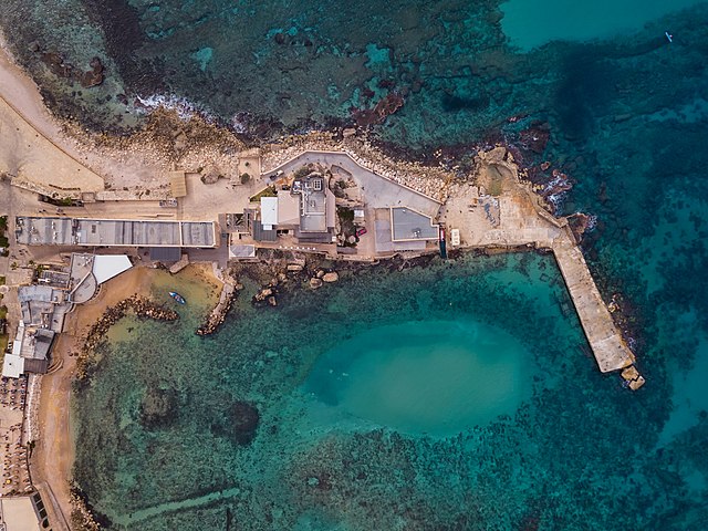
עברית: הנמל העתיק שהוקם לפני כ-2,000 שנה על ידי המלך הורדוס. ניתן למצוא בו עוגנים עתיקים, שרידים ועמודי שיש שונים. English: Caesarea Maritima was an ancient city in the Sharon Plain on the coast of the Mediterranean.
|
||
Date | |||
Source | Own work | ||
Author | Idomeir |
Camera location | 32° 30′ 07.55″ N, 34° 53′ 22.81″ E | View this and other nearby images on: OpenStreetMap | 32.502097; 34.889670 |
---|
Licensing[edit]
- You are free:
- to share – to copy, distribute and transmit the work
- to remix – to adapt the work
- Under the following conditions:
- attribution – You must give appropriate credit, provide a link to the license, and indicate if changes were made. You may do so in any reasonable manner, but not in any way that suggests the licensor endorses you or your use.
- share alike – If you remix, transform, or build upon the material, you must distribute your contributions under the same or compatible license as the original.
This image was one of 48 finalists in the national contest of Israel in "Wiki Loves Monuments 2018"
|
תמונה זאת הייתה אחת מ-48 התמונות שהגיעו לשלב הסופי בישראל של תחרות "ויקיפדיה אוהבת אתרי מורשת" לשנת 2018
|
This image was uploaded as part of Wiki Loves Monuments 2018.
Afrikaans ∙ Alemannisch ∙ azərbaycanca ∙ Bahasa Indonesia ∙ Bahasa Melayu ∙ Bikol Central ∙ bosanski ∙ brezhoneg ∙ català ∙ čeština ∙ Cymraeg ∙ dansk ∙ davvisámegiella ∙ Deutsch ∙ eesti ∙ English ∙ español ∙ Esperanto ∙ euskara ∙ français ∙ Frysk ∙ Gaeilge ∙ galego ∙ hrvatski ∙ Ido ∙ italiano ∙ latviešu ∙ Lëtzebuergesch ∙ Malagasy ∙ magyar ∙ Malti ∙ Nederlands ∙ norsk ∙ norsk nynorsk ∙ norsk bokmål ∙ polski ∙ português ∙ português do Brasil ∙ română ∙ shqip ∙ sicilianu ∙ slovenčina ∙ slovenščina ∙ suomi ∙ svenska ∙ Tagalog ∙ Türkçe ∙ Yorùbá ∙ Zazaki ∙ Ελληνικά ∙ беларуская ∙ беларуская (тарашкевіца) ∙ български ∙ кыргызча ∙ македонски ∙ русский ∙ српски / srpski ∙ українська ∙ ქართული ∙ հայերեն ∙ नेपाली ∙ हिन्दी ∙ বাংলা ∙ മലയാളം ∙ ไทย ∙ 한국어 ∙ +/− |
This image has been assessed using the Quality image guidelines and is considered a Quality image.
العربية ∙ جازايرية ∙ беларуская ∙ беларуская (тарашкевіца) ∙ български ∙ বাংলা ∙ català ∙ čeština ∙ Cymraeg ∙ Deutsch ∙ Schweizer Hochdeutsch ∙ Zazaki ∙ Ελληνικά ∙ English ∙ Esperanto ∙ español ∙ eesti ∙ euskara ∙ فارسی ∙ suomi ∙ français ∙ galego ∙ עברית ∙ हिन्दी ∙ hrvatski ∙ magyar ∙ հայերեն ∙ Bahasa Indonesia ∙ italiano ∙ 日本語 ∙ Jawa ∙ ქართული ∙ 한국어 ∙ kurdî ∙ Lëtzebuergesch ∙ lietuvių ∙ македонски ∙ മലയാളം ∙ मराठी ∙ Bahasa Melayu ∙ Nederlands ∙ Norfuk / Pitkern ∙ polski ∙ português ∙ português do Brasil ∙ rumantsch ∙ română ∙ русский ∙ sicilianu ∙ slovenčina ∙ slovenščina ∙ shqip ∙ српски / srpski ∙ svenska ∙ தமிழ் ∙ తెలుగు ∙ ไทย ∙ Tagalog ∙ Türkçe ∙ toki pona ∙ українська ∙ vèneto ∙ Tiếng Việt ∙ 中文 ∙ 中文(简体) ∙ 中文(繁體) ∙ +/− |
File history
Click on a date/time to view the file as it appeared at that time.
Date/Time | Thumbnail | Dimensions | User | Comment | |
---|---|---|---|---|---|
current | 06:50, 16 September 2018 | 3,992 × 2,992 (8.44 MB) | Idomeir (talk | contribs) | User created page with UploadWizard |
You cannot overwrite this file.
File usage on Commons
The following 7 pages use this file:
- Wiki Loves Monuments 2018 winners
- User:Geagea/Israel/2018 September 16
- User talk:Idomeir
- Commons:Featured picture candidates/File:מבט על נמל קיסריה.jpg
- Commons:Featured picture candidates/Log/January 2022
- Commons:Quality images/Technical/Composition
- Commons:Quality images candidates/Archives January 14 2020
File usage on other wikis
The following other wikis use this file:
- Usage on fa.wikipedia.org
- Usage on he.wikipedia.org
- קיסריה
- גנים לאומיים בישראל
- ויקיפדיה:תמונה מומלצת/המלצות קודמות/יוני 2019
- ויקיפדיה:תמונה מומלצת/הוספה למומלצים/ארכיון 121
- תבנית:תמונה מומלצת 23 ביוני 2019
- ויקיפדיה:תמונה מומלצת/המלצות קודמות/יוני 2020
- תבנית:תמונה מומלצת 16 ביוני 2020
- ויקיפדיה:תמונה מומלצת/המלצות קודמות/יוני 2022
- תבנית:תמונה מומלצת 1 ביוני 2022
Metadata
This file contains additional information such as Exif metadata which may have been added by the digital camera, scanner, or software program used to create or digitize it. If the file has been modified from its original state, some details such as the timestamp may not fully reflect those of the original file. The timestamp is only as accurate as the clock in the camera, and it may be completely wrong.
Camera manufacturer | DJI |
---|---|
Camera model | FC220 |
Exposure time | 1/1,250 sec (0.0008) |
F-number | f/2.2 |
ISO speed rating | 100 |
Date and time of data generation | 10:55, 22 December 2017 |
Lens focal length | 4.73 mm |
Latitude | 32° 30′ 7.55″ N |
Longitude | 34° 53′ 22.81″ E |
Altitude | 173.798 meters above sea level |
City shown | Caesarea |
Horizontal resolution | 240 dpc |
Vertical resolution | 240 dpc |
Software used | Adobe Photoshop Lightroom 6.9 (Macintosh) |
File change date and time | 11:15, 30 December 2017 |
Exposure Program | Manual |
Exif version | 2.3 |
Date and time of digitizing | 10:55, 22 December 2017 |
APEX shutter speed | 10.287712 |
APEX aperture | 2.275007 |
APEX exposure bias | −0.7 |
Maximum land aperture | 2.27 APEX (f/2.2) |
Subject distance | 0 meters |
Metering mode | Center weighted average |
Light source | Unknown |
Flash | Flash did not fire, No flash function |
Color space | sRGB |
File source | Digital still camera |
Scene type | A directly photographed image |
Exposure mode | Manual exposure |
White balance | Auto white balance |
Digital zoom ratio | 0 |
Focal length in 35 mm film | 26 mm |
Scene capture type | Standard |
Scene control | None |
Contrast | Soft |
Saturation | Low saturation |
Sharpness | Soft |
Subject distance range | Unknown |
GPS tag version | 0.0.3.2 |
Lens used | 26.3 mm f/2.2 |
Serial number of camera | 2016041101 |
Date metadata was last modified | 13:15, 30 December 2017 |
Unique ID of original document | DD716B2499887E3CDB07277C69A3643B |
Province or state shown | Haifa District |
Country shown | Israel |
Code for country shown | IL |
IIM version | 4 |
Structured data
Items portrayed in this file
depicts
32°30'7.549"N, 34°53'22.812"E
22 December 2017
0.0008 second
2.2
4.73 millimetre
100
image/jpeg
- Heritage sites in Israel with known IDs
- Heritage sites in Israel missing SDC depicts
- Heritage sites in Israel missing SDC location of creation
- Files with coordinates missing SDC location of creation
- CC-BY-SA-4.0
- Self-published work
- Images from Wiki Loves Monuments 2018
- Images from Wiki Loves Monuments 2018 in Israel
- Images from Wiki Loves Monuments missing SDC depicts
- Images from Wiki Loves Monuments missing SDC location of creation
- Quality images
- Quality images missing SDC depicts
- Uploaded via Campaign:wlm-il
- Taken with DJI FC220
- Quality images of Israel
- Israel photographs taken on 2017-12-22
- Pages with maps