Commons:Valued image candidates/Via appia.jpg

From Wikimedia Commons, the free media repository
Jump to navigation Jump to search

Via appia.jpg

promoted
Image
Nominated by Kleuske (talk) on 2010-07-20 15:18 (UTC)
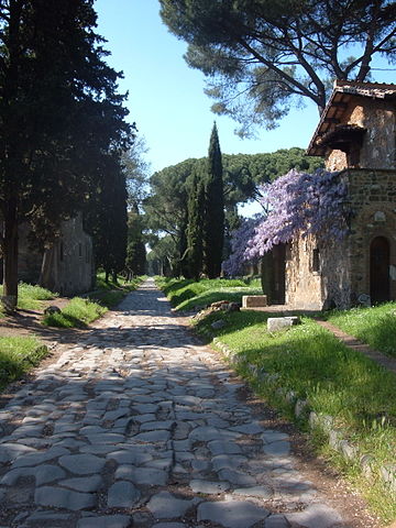
Scope Nominated as the most valued image on Commons within the scope:
Via Appia
Used in Global usage
Reason The usage across many projects made me do it. Besides, i like the picture. -- Kleuske (talk)
Review
(criteria)
  •  Info I took the liberty of adding a link to the Commons category in the scope to ease the comparison for the reviewers. --Myrabella (talk) 15:28, 20 July 2010 (UTC)[reply]
  •  Oppose, the given location is nonsense. --Ikar.us (talk) 17:12, 20 July 2010 (UTC)[reply]
    •  InfoFixed. Relative newcomer to geolocation and i took some things for granted i shouldn't have. Thanks for pointing it out. Kleuske (talk)
      • Thank you (and please apologize the rude word). Looks much better now, but are you sure it's the exact location? Can't really recognize the situation on the image. In which direction are we looking? --Ikar.us (talk) 20:02, 20 July 2010 (UTC)[reply]
        • The location is approximate, but shouldn't be much further than a few hundred metres off. The picture is facing northwest, towards the city. Time of Day is around 7 in the afternoon, late April. Kleuske (talk) 20:12, 20 July 2010 (UTC)[reply]
          • The alley on the satellite image looks like a one lane tarmac street, about 4m wide. The crossing with the road 500m to the south-east confirms that it's probably the same surface. That makes me suspect that we're somehow wrong... --Ikar.us (talk) 20:43, 20 July 2010 (UTC)[reply]
        • I'm absolutely sure there's no tarmac on the Via Appia Antica at all, except very near The City (instead of IV Miglio) and near the latter, it's strictly ancient pavement (see OpenStreetMap, which lists it as 'pedestrian'). I'm positive the location is near the crossing with Via Ercole Attico, since i ate there and took this picture not long afterward, along with some others. It may be a bit further up the road than indicated, but not much.
  • I don't understand the category structure. Category:Via Appia should be parent to the others, shouldn't it? And there are categories for places located near the Via Appia among those for the street itself. This image fulfills all criteria, haven't found one that looks better.  Support. --Ikar.us (talk) 01:25, 21 July 2010 (UTC)[reply]
    • The category structure is a mess. I've started a discussion to rectify it, but i don't want to proceed without at least some form of consensus. The proposed location looks good, b.t.w. The Appia Antica at that spot is for pedestrian/bicycle and local traffic onlyn (anlieger frei), IIRC (OpenStreetMap concurs). Kleuske (talk) 07:41, 21 July 2010 (UTC)[reply]
Result: 1 support, 0 oppose =>
promoted. George Chernilevsky talk 16:27, 24 July 2010 (UTC)
[reply]